
Jabalpur (district)
| Jabalpur District ( Hindi जबलपुर जिला ) |
|
|---|---|

|
|
| State | Madhya Pradesh |
| Division : | Jabalpur |
| Administrative headquarters : | Jabalpur |
| Area : | 5,211 km² |
| Residents : | 2,463,289 (2011) |
| Website : | Jabalpur district |
The district of Jabalpur ( Hindi जबलपुर जिला ) is a district of the central Indian state of Madhya Pradesh . The administrative center is the city of Jabalpur , which has a population of around 1.3 million .
geography
The Jabalpur district is bounded in places in the west by the Hiran River , in the southwest by the Narmada and Soner rivers and in sections in the southeast by the Mahanadi River . The Narmada River flows across the south of the district and is dammed in the south-east to form the Bargi Dam . Neighboring districts are Damoh district in the northwest , Narsimhapur district in the southwest , Seoni district in the south, Mandla district in the southeast , Dindori and Umaria district in the east, Katni district in the northeast and Panna district in the north .
The Jabalpur District is divided into seven administrative districts ( Tehsils or Subdivisions ): Majhoti, Sihora, Patan, Panagar, Kundam, Shahpura and Jabalpur; it consists of around 250 larger villages, a city of millions and only three smaller cities - Sihora (approx. 40,000 inhabitants), Patan (approx. 20,000 inhabitants) and Kundam (approx. 5,000 inhabitants).
The average altitude of the district is between 200 and 450 meters above sea level. d. M; the maximum height is around 550 m.
population
Official population statistics have only been kept and published since 1991.
| year | 1991 | 2001 | 2011 |
| Residents | 1,768,037 | 2,151,203 | 2,463,289 |
Hindus dominate the rural villages (around 90%); There is also a not inconsiderable number of Muslims in the cities (around 20%). In the decade between 2001 and 2011, the population grew by around 14.5% to around 2.5 million, with the male population exceeding that of the female population by around 10%. Only about 42% of the population lives in rural villages; an average of 20% of people (significantly more in rural areas) are illiterate. They speak Hindi and the local dialect Bagheli .
economy
Despite the high proportion of urban population, the Jabalpur district is still largely agricultural; only in the megacity of Jabalpur are there various industrial companies. The city also has an airport; There are train stations in Jabalpur and Sihora.
history
The region around Jabalpur belonged in the 4th / 5th centuries. Century to the Gupta Empire , which was later replaced by the kings of the Kalachuri dynasty. In the High Middle Ages, the Gond rulers took power; however, they later came under the political and cultural influence of the Mughal Empire . After that, the region came under the influence of the Marathas in the 17th and 18th centuries ; since the middle of the 19th century the area was under British control. After India's independence (1947), the Jabalpur district came to the state of Madhya Pradesh.
Attractions
There are two Gupta temples , Tigawa and Kunda, in the Jabalpur district, which has hardly been developed for tourism ; in addition, the Yogini Temple of Bhedaghat is of historical and cultural interest. In Jabalpur itself there is the Madan Mahal Fort and a regional museum that is well worth seeing ( Rani Durgavati Museum ). A popular destination are the Marble Rocks , a rock breakthrough in the Narmada River near Bhedaghat.
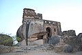
Jabalpur, Madan Mahal Fort

Tigawa , Kankali Devi Temple
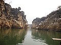
Marble Rocks


Gupta-Tempel.jpg)


Web links
- Jabalpur District - Census 2011
- Jabalpur District - Census 2011 etc.
- Jabalpur District - Overview Map
Individual evidence
- ^ Jabalpur District - Map
- ^ Jabalpur district - map with elevation information
- ^ Jabalpur District - Census 1991 to 2011
- ↑ Jabalpur District - Census 2011
Small text

Agar Malwa | Alirajpur | Anuppur | Ashoknagar | Balaghat | Barwani | Betul | Bhind | Bhopal | Burhanpur | Chhatarpur | Chhindwara | Damoh | Datia | Dewas | Dhar | Dindori | Guna | Gwalior | Harda | Hoshangabad | Indore | Jabalpur | Jhabua | Katni | Khandwa | Khargone | Mandla | Mandsaur | Morena | Narsinghpur | Neemuch | Panna | Raise | Rajgarh | Ratlam | Rewa | Sagar | Satna | Sehore | Seoni | Shahdol | Shajapur | Sheopur | Shivpuri | Sidhi | Singrauli | Tikamgarh | Ujjain | Umaria | Vidisha