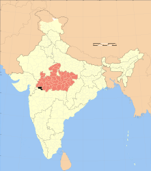
Barwani (District)
| Barwani District | |
|---|---|

|
|
| State | Madhya Pradesh |
| Administrative headquarters : | Barwani |
| Area : | 5427 km² |
| Residents : | 1,385,881 (2011) |
| Population density : | 255 people / km² |
| Website : | www.barwani.in |
Barwani is a district in the Indian state of Madhya Pradesh .
The area is 5427 km². The administrative seat is the city of Barwani with 55,504 inhabitants.
history
The district used to belong to the princely state of Barwani . This was founded in the 11th century by Sisodia - Rajputs from Mewar / Udaipur and was dissolved in 1948. The modern district emerged in 1998 when it was separated from the Khargone district (West Nimar district).
population
The population was 1,385,881 (2011). The population growth rate in the period from 2001 to 2011 was 27.57%, which is very high. Barwani has a gender ratio of 950 women per 1000 men and thus a male surplus typical for India. The district had a literacy rate of 49.08% in 2011 , an increase of almost 9 percentage points compared to 2001. This means that literacy is well below the national average. Almost 95.2% of the population are Hindus , approx. 4.2% are Muslims , 0.2% each are Christians , Sikhs , Jainas and 0.1% said they did not belong to any religion or belonged to other religions. 19.1% of the population are children under 6 years of age.
Almost 17.2% of the population live in cities.
Web links
Individual evidence
- ↑ 2011 census (PDF; 398 kB)
- ^ Indian Districts by Population, Sex Ratio, Literacy 2011 Census. Retrieved April 16, 2019 .
Small text
