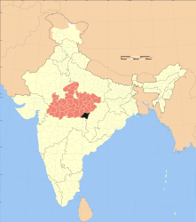
Balaghat (District)
| Balaghat District | |
|---|---|

|
|
| State | Madhya Pradesh |
| Administrative headquarters : | Balaghat |
| Area : | 9229 km² |
| Residents : | 1,701,698 (2011) |
| Population density : | 184 inhabitants / km² |
| Website : | www.balaghat.in |
Balaghat is a district in the Indian state of Madhya Pradesh .
The area is 9229 km². The administrative seat is the city of Balaghat with 84,261 inhabitants.
population
The population in 2011 was 1,701,698. The population growth rate in the period from 2001 to 2011 was 13.60%. Balaghat has a gender ratio of 1021 women per 1000 men and thus a rare excess of women for India. The district had a literacy rate of 77.09% in 2011 , an increase of almost 9 percentage points compared to 2001. The literacy rate is thus above the national average. Almost 89.3% of the population are Hindus , approx. 4.2% are Buddhists , approx. 2.3% are Muslims , 0.3% are Christians , 0.3% are Jainas , and 3.8% have no religious affiliation belonged to or belonged to other religions. Children under 6 years of age are 12.5% of the population.
Almost 14.4% of the population live in cities.
economy
The district is manganese mined. Bauxite , kyanite , marble , dolomite , clay and limestone are the other minerals that occur.
Web links
Individual evidence
- ↑ 2011 census (PDF; 398 kB)
- ^ Indian Districts by Population, Sex Ratio, Literacy 2011 Census. Retrieved April 16, 2019 .
Small text
