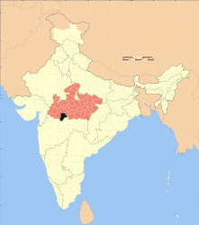
Khandwa (District)
| Khandwa District ( Hindi खंडवा जिला ) |
|
|---|---|

|
|
| State | Madhya Pradesh |
| Division : | Indore |
| Administrative headquarters : | Khandwa |
| Area : | 7350 km² |
| Residents : | 1,309,443 (2011) |
| Population density : | 178 inhabitants / km² |
| Website : | Khandwa District |
The Khandwa District ( Hindi खंडवा जिला - also known as the East Nimar District ) is a district of the central Indian state of Madhya Pradesh . The administrative and economic center is the city of Khandwa with a population of around 220,000 .
geography
The district of Khandwa is located in the south of the state of Madhya Pradesh and borders on the district of Amaravati in the state of Maharashtra in the southeast . To the south the district is bounded by the Burhanpur district ; to the west borders the district of Khargone , to the north the district of Dewas and to the east the district of Harda .
The Khandwa District is divided into five administrative districts ( Tehsils or Subdivisions ): Harsud, Khalwa, Khandwa, Pandhana, and Punasa / Mundi with a total of more than 700 villages and - in addition to the city of Khandwa - only four medium-sized or smaller cities: Chhanera (approx . 25,000), Mundi (approx. 15,000), Omkareshwar (approx. 13,000) and Pandhana (approx. 15,000 inhabitants).
The northern part of the 250 to 350 m high district with the holy city of Omkareshwar borders the Narmada River . In the east, the Narmada and several tributaries are dammed up to the Indira Gandhi Reservoir , which is the largest reservoir in India with a maximum capacity of 12.2 billion cubic meters. The Satpura Mountains rise to the south . The annual rainfall amounts to approx. 950 mm / year, of which approx. 90% is accounted for by the summer monsoon months .
population
Due to the ongoing population growth in India and immigration, the population of the district has increased enormously in the last few decades:
| year | 1991 | 2001 | 2011 |
| Residents | 898.596 | 1,078,251 | 1.310.061 |
Hindus dominate the rural villages (about 98%); about 15 to 20% of the urban population are Muslims . In the decade between 2001 and 2011 the population grew by a good 20% to around 1.31 million, with the male population exceeding the female population by around 5%. About 80% of the population lives in rural villages; more than a third of people (mostly women) are illiterate. They speak Hindi and the regional dialect Nimadi , a Bhil language.
economy
According to official statistics, the Khandwa District is one of the 250 most backward of a total of 640 districts in India. It is characterized by agriculture to a very high degree, with migrant workers also playing a not unimportant role to this day. Only in the few cities are there a few larger shops and craft businesses as well as banks and secondary schools. Khandwa is an important rail hub. The villages are connected to the regional transport network by bus routes.
history
The old region of Nimar has been dominated by foreign powers ( Mauryas , Shungas , Shatavahanas , Kardamakas, Abhiras, Vakatakas , Guptas , Kalachuris , Vardhanas, Chalukyas , Rashtrakutas , Paramaras etc.) Raja Ali Khan (ruled 1576–1596) since ancient times the Faruqi dynasty ruled in the neighboring region of Khandesh to the west , which also included the city of Burhanpur , located south of Khandwa , and submitted to the Mughal Mughal Akbar I in 1577 ; his son Bahadur Khan (r. 1596–1600) did not recognize the sovereignty of the Mughal empire and was defeated by the Mughal army in 1600 almost without a fight. After the death of the last great Mughal ruler Aurangzeb (1707) the Mughal empire fell apart; the region around Burhanpur and Khandwa came to the Marathan Empire in 1740 . The area had been under British control since 1818 . After India's independence (1947), the region came to the newly created state of Madhya Pradesh in the form of the East Nimar district (old name). On August 11, 2003, the East Nimar district was divided into the two districts of Burhanpur and Khandwa.
Attractions
In the area of the Kandwa district, which is otherwise hardly developed for tourism, is the temple town of Omkareshwar , which is particularly sacred to the followers of the Hindu god Shiva because one of 12 Jyotirlingas is worshiped here. Trips to Indore or Burhanpur are recommended.
Web links
Individual evidence
- ↑ Khandwa District - Map etc.
- ↑ Khandwa District - Cities
- ↑ Khandwa District - Villages
- ↑ Khandwa District - Map with elevation information
- ↑ Khandwa - climate diagrams
- ^ Khandwa District - Population 1991–2011
- ↑ Khandwa District - Population
- ↑ Khandwa District History
- ^ District Census Handbook Burhanpur. (PDF) Census of India 2011, accessed on December 25, 2017 .
Small text

