Tikamgarh
| Tikamgarh | ||
|---|---|---|
|
|
||
| State : |
|
|
| State : | Madhya Pradesh | |
| District : | Tikamgarh | |
| Location : | 24 ° 45 ' N , 78 ° 51' E | |
| Height : | 658 m | |
| Residents : | 79,106 (2011) | |
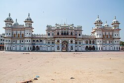
| Temple of Janaki | ||
Tikamgarh is a city in the Indian state of Madhya Pradesh . The city is located in the north of the state and is part of the Bundelkhand region .
The city is the administrative center of the Tikamgarh district of the same name . Tikamgarh has the status of a Municipal Council. The city is divided into 27 wards (constituencies).
history
Tikamgarh, formerly known as Tehri, was part of the Orchha Kingdom that was founded in the 16th century by Rudra Pratap Singh , a bundela who became the first king of Orchha. In 1783 the capital of the state was relocated to Tehri, some 40 miles south of Orchha, where the fort of Tikamgarh was located. The city eventually got the name of the fort.
Demographics
The population of the city is 79,106 according to the 2011 census. Tikamgarh has a gender ratio of 911 women per 1000 men and thus a male surplus typical for India. The literacy rate was 85.0% in 2011 and thus above the regional and national average. Almost 70% of the population are Hindus , around 21% are Muslims and around 9% are Jainas . Children under 6 years of age are 11.9% of the population.
Infrastructure
The city has had its own rail link since 2012.
Individual evidence
- ↑ www.census2011.co.in
- ↑ Tikamgarh Municipality City Population Census 2011-2019 | Madhya Pradesh. Retrieved September 18, 2019 .

