Mandla
| Mandla | ||
|---|---|---|
|
|
||
| State : |
|
|
| State : | Madhya Pradesh | |
| District : | Mandla | |
| Location : | 22 ° 36 ' N , 80 ° 23' E | |
| Height : | 445 m | |
| Residents : | 49,463 (2011) | |
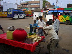
| Sugar cane press in front of the Mandla bus station | ||
Mandla ( Hindi : मंडला) is a city in the Indian state of Madhya Pradesh and lies on a loop of the Narmada River .
The national highway NH 12A connects the city with the next largest city of Jabalpur, which is almost 100 km away . A car journey usually takes less than three hours. Approx. Kanha National Park is 40 km southeast of the city . There is a connection to the railway network.
population
According to the 2011 census, Mandla has 49,463 inhabitants.

