Datia (city)
| Datia दतिया |
||
|---|---|---|
|
|
||
| State : |
|
|
| State : | Madhya Pradesh | |
| District : | Datia | |
| Sub-district : | Datia | |
| Location : | 25 ° 40 ′ N , 78 ° 27 ′ E | |
| Height : | 350 m | |
| Area : | 6.64 km² | |
| Residents : | 100,284 (2011) | |
| Population density : | 15,103 inhabitants / km² | |
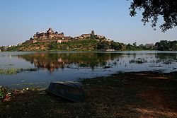
| Datia - Bir Singh Deo Palace | ||
Datia ( Hindi दतिया ) is a city with around 120,000 inhabitants in the Indian state of Madhya Pradesh and at the same time the administrative seat of the district of the same name .
Location and climate
The city of Datia is located approx. 100 km (driving distance) southeast of Gwalior and only approx. 28 km northwest of Jhansi at an altitude of approx. 350 m . The climate is temperate to warm; Rain (approx. 940 mm / year) falls mainly in the summer monsoon season .
Population development
| year | 1991 | 2001 | 2011 |
| Residents | 64,477 | 82,755 | 100.284 |
As a result of the mechanization of agriculture and the abandonment of smallholder farms, unemployment and rural poverty have risen significantly; many people therefore seek their happiness in the cities ( rural exodus ). Approx. 87% of the population are Hindus and about 11.5% are Muslims ; the rest is made up of Buddhists , Jains , Sikhs and Christians . The male part of the population exceeds the female population by approx. 10%. One speaks Hindi and Bundeli .
economy
The inhabitants of the big city and its surrounding area live primarily directly or indirectly from agriculture; Retail trade, handicrafts and day laborers dominate the city.
history
According to some, Datia is already mentioned in the Mahabharata as Daityavakra . Medieval news is missing. Raja Bir Singh had one of his many palaces built above an artificial lake near the city at the beginning of the 17th century. The princely state of Datia was created through the division of inheritance in 1626 and lasted - even under British rule - until India's independence. He then joined the Princely Union of Vindhya Pradesh , which was dissolved in 1956 and became part of the newly created state of Madhya Pradesh.
Attractions
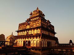
- The most important sight of the city is the Raja-Bir-Singh-Palace, built on a hill above an artificial lake in the Indo-Islamic style . The multi-storey square central palace building that ends in a domed building with a corner chhatris is particularly noteworthy, which is unique in India.
- Also noteworthy is the Rajgarh Palace - part of a former fortress with beautiful views over the city.
- Surroundings
- Approx. 16.5 km northwest of the city is the Jain sanctuary of the Sonagiri Hills, consisting of 77 temples .
- In Unao, about 16 km to the southeast, there is one of India's rather rare sun temples .
- Approx. 5 km west of Unao is the village of Gujarra with a short Ashoka inscription .
Web links
- Datia, attractions - Photos and brief information (English)
- Datia, attractions - Photos and brief information (English)


