
Chaos de Montpellier-le-Vieux

The Chaos de Montpellier-le-Vieux is a rock formation used by tourists in the French department of Aveyron .
geography
The rock formation is located in the western part of the department on the high plateau of the Causse Noir . To the north are the Tarn and Jonte rivers , to the south are the Dourbie gorges and to the west is the city of Millau .
nature
The rock accumulation covers about 120 hectares. They were created by corrosion of the dolomite rock of the Causse Noir. Originally it was assumed that the rocks were a ruined city, only in 1870 a swath was cut to the rocks. The speleologist Edouard-Alfred Martel was the first to map the rocks in 1883–1884.
photos
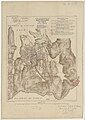
Topographic map (1:10 000) by Édouard-Alfred Martel, 1885.

Porte de Mycène
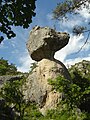
Roc Camparolié

Arc de triomphe
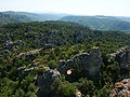
View from Le Douminial .

Mini train through the rocks.
.jpg)


Web links
Coordinates: 44 ° 8 ′ 13 ″ N , 3 ° 12 ′ 10 ″ E