Charkhari (State)
| Charkhari | |||||
| 1765-1950 | |||||
|
|||||
| Capital | Charkhari | ||||
| Form of government | Princely state (11 shot salute) | ||||
| surface | 2279 km² | ||||
| population | 123,000 (1901) | ||||
| founding | 1765 | ||||
| resolution | January 1, 1950 | ||||
| State religion: Hinduism Dynasty: Bundela |
|||||
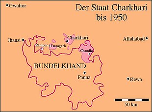
| Map of Charkhari | |||||
| Charkhari postage stamp from 1897 | |||||
Charkhari was a princely state in the Bundelkhand region of British India . It was created in 1765 from an inheritance from the princely state of Panna of the Bundela dynasty. Raja Bikramajit Singh (1782–1829) placed himself under British protection in 1804. Ratan Singh (1829-1860) supported the British in the great Indian uprising of 1857 , which earned him additional land. Charkhari now comprised the city of the same name and 504 villages on 2279 km² and had about 123,000 inhabitants. Since Malkhan Singh Ju Deo Bahadur (1880-1908), the rulers carried the title of Maharajadhiraj .
On April 4, 1948, Charkhari joined the Princely Union of Vindhya Pradesh , and on January 1, 1950, it joined India . At the same time it had to cede the northern exclaves including the city of Charkhari to the state of Uttar Pradesh . On November 1, 1956, all princely states were dissolved and Vindhya Pradesh was incorporated into the state of Madhya Pradesh .
Charkhari had a state post with its own stamps from 1894 to 1949.
literature
- William Barton: The princes of India. With a Chapter on Nepal. Nisbet, London 1934, (Reprinted edition. Cosmo, New Delhi 1983).
- Andreas Birken : Philatelic Atlas of British India. CD-ROM. Birken, Hamburg 2004.
- Charkhari State. In: The Imperial Gazetteer of India. Volume 10: Central Provinces to Coompta. New Edition. Clarendon Press, Oxford 1908, pp. 176-179 .
- George B. Malleson: An historical sketch of the native states of India. Longmans, Green & Co., London 1875, ( digitized version ).
- Paul E. Roberts: India (= A Historical Geography of the British Dominions. Vol. 7, Part. 1-2). 2 volumes (Vol. 1: History to the End of the East India Company. Vol. 2: History under the Government of the Crown. ). Clarendon Press, Oxford 1916-1923, (Reprinted edition: Historical Geography of India. 2 volumes. Printwell, Jaipur 1995).
- Joseph E. Schwartzberg (Ed.): A historical atlas of South Asia (= Association for Asian Studies. Reference Series. 2). 2nd impression, with additional material. Oxford University Press, New York NY et al. 1992, ISBN 0-19-506869-6 .
Web links
- iiNet: Charkhari (Princely State)
- Imperial Gazetteer of India
- http://www.uq.net.au/~zzhsoszy/ips/main.html
- http://www.worldstatesmen.org/India_princes_A-J.html
- Falling Rain Genomics, Inc - Charkhari (English)
Coordinates: 25 ° 24 ' N , 79 ° 45' E


