City of Rocks State Park
|
City of Rocks State Park
|
||
|
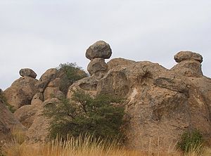
Rock formation (December 2006) |
||
| location | Grant County in New Mexico (USA) | |
| surface | 2 km² | |
| Geographical location | 32 ° 35 ′ N , 107 ° 58 ′ W | |
|
|
||
| Setup date | 1952 | |
| administration | New Mexico Energy, Minerals and Natural Resources Dept. | |
The City of Rocks State Park in the American Southwest was founded in May 1952. It covers a relatively small area of only approx. 2 km² and is located at an altitude of around 1800 m in the Chihuahuan Desert Region in southwest New Mexico between Deming and Silver City in Grant County northeast of the intersection of US Highway 180 with State Route 61 .
The park is visited by around 50,000 people a year, most of whom use the campsite , which is embedded in the rock formation.
The attraction of the park are the large granite boulders that rise up to 15 meters and are separated from each other by narrow paths. The rock formations in the park are geologically very extraordinary.
Emergence
The rocks were formed during a major volcanic eruption around 35 million years ago. Through the erosion over many millions of years, the rocks were brought into their present form.
history
Around the year 1200 Mimbres Indians settled this area and left arrowheads and shards of clay pots behind. Spanish conquistadors passed the rocks and reported about it. In May 1952 the state park was established.
Web links
- City of Rocks State Park near New Mexico State Parks (New Mexico Energy, Minerals and Natural Resources Dept.)
- City of Rocks State Park (English)
- http://www.newmexico.org (English)
- Pictures and description of the City of Rocks SP (German)
- City of Rocks State Park in the United States Geological Survey's Geographic Names Information System


