Clapham Junction (Malta)
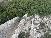
The Clapham Junction ( Maltese: Misraћ Gћar il-Kbir ), also known as Cart Ruts, is an accumulation of prehistoric drag marks in the south of the island of Malta . The history of their origins and the meaning of the tracks are controversial.
It is generally believed today that it was at the beginning of the 2nd millennium BC. BC originated, d. H. during the Bronze Age , the beginning of which in Malta coincides with a repopulation of the islands abandoned 500 years ago.
Since some traces of grinding are interrupted by Phoenician grave shafts, their emergence is after the beginning of Phoenician settlement around 800 BC. Unlikely. Together with the megalithic temples on the archipelago , they belong to the still incompletely explored archaeological ground monuments from the early history of Malta .
The systems owe their name to the fact that an Englishman who reported on them felt reminded of the layout of the tracks in the station of the same name in London when he saw them .
The grooves
The parallel grooves can be found on Malta and Gozo (Il-Bajja tal-Mellieħa, Ras il-Qala, Ta 'Blankas, Ta' Cenc); however, the most impressive is the Clapham Junction, located at the Dingli Cliffs in southern Malta.
The tracks, which are always worked into the limestone in pairs, are up to 50 cm deep and are 110 to 140 cm apart. The grooves, which are reminiscent of tracks, sometimes cross, some branch or form "switches", which reinforces the impression of railroad tracks.
interpretation
In the absence of an obvious explanation for the purpose of the "rails", a number of theories have emerged. The most common are the following:
- here goods were transported on sleds, which caused the grinding marks in the stone
- they are tracks built into the ground for carts in which goods were transported
- it is an irrigation system.
Sledge or cart tracks
The following argument is made against the theory of grinding marks produced by slides:
In order to create the deep grinding marks, the sleds would have to have been loaded with heavy goods. A corresponding amount of force would have to be used to move such sleds. The low population density of Malta at the time and thus the lack of workers counter this. A cart, on the other hand, would have had to have wheels with a diameter of at least about 1.4 m (regardless of what is being carried on it) and thus could not have followed the curve radius of the deep grooves.
A variant of this theory suggests that the means of transport was used to bring large blocks of limestone to the construction sites of the megalithic temples. However, this theory also has flaws:
The grinding marks can be found in countless places on the island, just not in the vicinity of temples. In this connection the possibility was now discussed that the blocks had been carried in the grooves on large balls carved from stone; however, the calculations showed that the balls could never have carried such a load.
Irrigation system
Another explanation points to the fact that the soil of Malta is relatively barren and there was a lack of water then as now. As the population grew, it could have become more difficult to provide for people. Therefore extensive irrigation systems could have been built for the fields. This is countered by the fact that a much larger population did not need a water supply (in this form) during the temple phase.
Other attempts at explanation
There are other attempts at explanation, each of which has weighty counter-arguments. The Maltese archaeologist Anthony Bonann dates the formation of the grooves to the 7th century BC. According to him, the grinding marks were devices of the Phoenicians. However, the number of traces cannot be reconciled with the comparatively small volume of Phoenician construction activity on Malta.
Another explanation is based on the observation that in most cases the tracks run towards the sea. Some sources even claim that the tracks can be traced to a depth of 70 m below sea level. However, the limestone, which is below sea level, has been severely attacked by waves, which makes it difficult to prove it. If the traces can actually be traced far below today's sea surface, this would mean that the traces are much older, as the sea level only began around 5000 BC. Has risen to today's level. This is why this hypothesis was taken up by Erich von Däniken , who believes he can see the take-off and landing sites of extraterrestrial beings in the tracks. Claims that Malta are the remains of the fabulous Atlantis are similarly speculative .
literature
- Joachim von Freeden: Malta and the architecture of its megalithic temples. Scientific Book Society, Darmstadt 1993, ISBN 3-534-11012-9 .
Web links
Individual evidence
- ^ David H. Trump : Malta: An Archaeological Guide. Progress Press Co. Ltd, 1991.
- ↑ a b See in the report Malta - cart ruts, OBSERVATIONS CARRIED OUT BY JOSEPH MAGRO CONTI AND PAUL C. SALIBA , www.angelfire.com
- ↑ Erich von Däniken: Prophet of the Past , ECON, 1979.
Coordinates: 35 ° 51 '8.1 " N , 14 ° 23' 48.8" E


