Gozo
| Gozo | |
|---|---|
| Gozo satellite image | |
| Waters | Mediterranean Sea |
| Archipelago | Maltese islands |
| Geographical location | 36 ° 3 ' N , 14 ° 15' E |
| length | 14 km |
| width | 7.25 km |
| surface | 67 km² |
| Highest elevation |
Ta 'Dbieġi 195 m |
| Residents | 31,446 (2015) 469 inhabitants / km² |
| main place | Victoria |
| Flag of Gozo | |
Gozo ([ ˈɡozo ], English [ ˈɡoʊ.zoʊ ], Maltese Għawdex [ ˈaʊːdeʃ ]) is the second largest island in the Maltese archipelago . It belongs to the Republic of Malta . The inhabitants of the island are called Gozitans.
history
Already in the 5th millennium BC there lived on Gozo . BC people who probably immigrated from Sicily . Before the middle of the 4th millennium, they built the Neolithic Ġgantija temple complex, one of the oldest in the archipelago, on the plateau south of today's Xagħra . Three thousand years later the Phoenicians gave the island the name "Göl", the following Greeks ( Hekataios of Miletus described Gozo around 500 BC as an island off the Carthaginian coast) graced it to Gaúlos (Γαύλος) or in the 4th century BC . Chr. Callimachus of Cyrene to Gaudos (Γαύδος). The Romans latinized it to "Gaulus". The current name is only known from the 14th century AD.
In July 1551, the Ottomans under Sinan Pascha and Turgut Reis attacked Gozo, they deported all able-bodied residents as slaves to Libya . The island's fortifications were then strengthened by the Order of Malta . Gozo was an important economic factor for the order, because on the Fungus Rock in front of the island they harvested the Maltese sponge , a plant which they ascribed to have hemostatic properties and which they sold on the European mainland in addition to their own use. It later turned out that the plant had no medicinal effects whatsoever.
When the Knights of Malta surrendered to Napoleon's troops without a fight under their Grand Master Ferdinand von Hompesch zu Bolheim in 1798 , the inhabitants of Gozo protested against the occupation of their island by the French. The soldiers who landed on the island in September were captured and detained in the citadel of Rabat. The following October, Gozo proclaimed its independence and gave itself the name “ La Nazione Gozitana ” (The State of Gozo). When the British took possession of the Maltese archipelago in September 1800, independence came to an end again. (See also main article: La Nazione Gozitana)
Gozo owes the British rule, among other things, the excavation of the -Tgantija temple, which was ordered by British island commander Otto Bayer in 1827, the renaming of its capital Rabat to Victoria in 1897 and the establishment of the city park of Victoria in 1915.
In 1987 Gozo regained a bit of autonomy when the island was raised to an independent administrative district together with its neighboring island Comino . A minister with his own budget was specially appointed for this administrative district.
Geography and infrastructure
Gozo is about six kilometers northwest of the main island of the Maltese archipelago. The surface area is 67 km², the longest extension is 14 kilometers, and the coastline is 43 kilometers long. In the western part, Gozo reaches its highest point at 176 meters.
Around 31,000 people live in fourteen towns, most of them in the island's capital Victoria (Rabat) with around 6,800 inhabitants. The other settlements, in which no more than 2000 people live, have a village character.
traffic
The connection to the island of Malta is ensured by car ferries such as the Gozo Channel Line , which shuttles back and forth between the port of Mġarr on Gozo and the ferry terminal Ċirkewwa on the northwest coast of Malta every 45 minutes during the day . At times there was a regular helicopter connection, which was implemented via the landing site at Xewkija , located five kilometers southeast of the island's capital, and the Luqa Airport on Malta. During the Second World War, a makeshift airfield was built for the American armed forces as part of the landing in Sicily. After two months of operation, it was abandoned and used again for agriculture. Since the late 1960s there have been repeated plans to build an airfield. Currently, there is a seaplane type de Havilland Canada DHC-3 of the Harbor Air Malta flying between the port of Mgarr and the Grand Harbor in Valletta.
Since the way to Malta is very complex for many residents (professionals and students), there were considerations in 2015 to build a tunnel or a bridge there. On the other hand, it was argued that the character of the island could then change significantly on Gozo. Financial and ideational considerations keep the discussion flowing.
On Gozo - as on the main island of Malta - there is left-hand traffic . Local public transport consists of a system of several bus lines. With the exception of line 322, which runs directly from the ferry port in Mġarr to Marsalforn, all of them start at the central bus station in Victoria and from there to the individual villages, mostly to the coast. The operator was Arriva for a good two years, a day ticket for tourists cost € 2.60, the weekly ticket € 6.50. Timetables with departure times and an overview map are provided free of charge in Victoria. The direct line 301 runs from Victoria to the ferry port Mġarr, the timetable of this line is adapted to the departure times of the individual ferries and therefore every 45 minutes. On January 2, 2014, local public transport was nationalized. The population regretted this because the network had improved from year to year, for example in terms of timing, punctuality and prices. However, the transport company had made a loss of 35 million euros since 2011. The nationalization at Transport Malta is only meant to be temporary.
economy
The main occupation on Gozo is agriculture, which employs around 1,000 people. For a quarter of them, however, it is only a sideline. After all, agriculture is so intensively practiced that Gozo can supply 60 percent of the entire Maltese archipelago with food. Sea salt extraction and sand-lime brick mining also play a role as economic factors. Tourism is becoming more and more important as a source of income.
Flora and fauna
Especially in the spring months, Gozo is much greener than its sister island Malta . This is due to three factors: On the one hand , more fertile soil has been deposited on the barren sand-lime stone , of which all the islands of Malta are made, than on Malta, which forms a basis for plant growth . Furthermore, there are several underground water resources on Gozo that could be drilled for the agricultural management of the country. And finally, the population density on Gozo is significantly lower than on Malta, so that larger open spaces remain between the cities.
The Gozitans therefore like to call their island the Green Island , although the vegetation still looks very sparse compared to Central European conditions. The English brought the smooth-leaved opuntia to Malta, which was not native here. Another plant that became indigenous to Gozo is nodding wood sorrel (Oxalis pes-caprae L., Syn .: Oxalis cernua Thunb.), Also called Bermuda wood sorrel or goat's sorrel, whose original home is South Africa.
religion
Of the island's over 30,000 inhabitants, 89% are Catholics. Since 1864 Gozo has its own diocese , the Diocese of Gozo . It is subordinate to the Archdiocese of Malta as a suffragan , has 15 parishes with 144 diocesan priests and 15 religious priests and an area of 67 km² . There are 89 nuns . (As of 2016) Ta 'Pinu is an important place of pilgrimage in the west of Gozo.
Attractions
West Gozo, the area called Dwejra, is the island's main attraction.
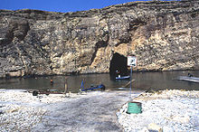
- The inland lake connected to the sea by a tunnel , a small salt water lake fed by the sea
- The Fungus Rock , home of the Maltese sponge
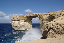
- The Azure Window (paints. Tieqa Żerqa ) was a naturally formed rock gate. It is no longer there after the collapse on March 8, 2017
- The salt pans
- The Kerċem Aqueduct
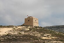
The Giordan Lighthouse , visible from afar on a mountain 150 meters above the sea, is the only lighthouse in Gozo. To the north of this on the coast is the Wied il-Mielah Window , another naturally formed rock gate.
On the north coast, east of Marsalforn , above Ramla Bay , lies the Calypso Cave (calypso grotto), which is said to have been where Odysseus lived with the nymph Calypso for seven years . The cave has been in danger of collapsing since 2011 and is closed to the public.
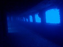
The diving areas of Gozo are among the best in the whole Mediterranean because of the magnificent underwater landscape, wrecks and caves and the clear view . The most famous dive sites are Xwejni Bay , Double Arch, Reqqa Point, Inland Sea , Blue Hole , Billinghurst Cave, Azure Window.
Archaeological monuments are
Culture
Despite a population of just 30,000, Gozo has two large historic opera houses. Both the Astra and the Aurora in Rabat hold regular opera festivals.
literature
- Heinz Gstrein : Malta, with Gozo and Comino (= Walter travel guide ). Herder, Freiburg im Breisgau a. a. 1992, ISBN 978-3-451-22758-5 .
- Hans E. Latzke: DuMont travel paperback Malta with Gozo and Comino . 3rd edition, DuMond, Ostfildern 2004, ISBN 978-3-7701-5972-7 .
- Werner Lips: Malta, Gozo, Comino . Reise-Know-How-Verlag Rump, Bielefeld - Brackwede 1999, ISBN 3-89416-659-2 .
Individual evidence
- ↑ NSO.gov.mt: Gozo in Figures 2015. Accessed May 30, 2017 .
- ↑ F.-C. Czygan: Flora under the Maltese cross . In: Deutsche Apothekerzeitung . No. 51 , 1999, p. 52 ( online ). Compare F. Freller: Fungus Melitensis, a legendary medicinal plant. Pharm. Ztg. 142 (1997) 4612-4614
- ↑ Source: Times of Malta, various reports, currently December 23, 2013, pp. 1 and 3.
- ^ Allied Newspapers Ltd: The Azure Window: lost and gone forever . In: Times of Malta . ( timesofmalta.com [accessed March 8, 2017]).
- ^ Ten Best Dive Sites in Europe , scubatravel.co.uk, accessed May 31, 2011
See also
Web links
- Gozo Ministry's Official Website (English and Maltese)
- Visit Gozo , official portal managed by the Ministry of Gozo
- Gozo , German language website about Gozo


