
Clare Island
| Clare Island | ||
|---|---|---|
.jpg) |
||
| Waters | Atlantic Ocean | |
| Geographical location | 53 ° 48 '18 " N , 9 ° 59' 37" W | |
|
||
| length | 7.8 km | |
| width | 4 km | |
| surface | 16.4 km² | |
| Highest elevation | Knockmore ( An Cnoc Mór ) 462 m |
|
| Residents | 168 (2011) 10 inhabitants / km² |
|
| main place | Capnagower | |
 |
||

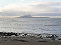
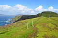
Clare Island ( Irish Cliara or Oileán Chliara ) is an island off the west coast of County Mayo in Ireland . It is located at the entrance of Clew Bay and is next to Achill Island and Inishturk the largest (16.4 km²) inhabited island. It is also the island with the highest elevation (461 meters) and the steepest cliffs in the bay and is about 3.5 miles from the nearest mainland port. There are still 168 people living on the small island (as of 2011). Clare lost half of its once more than 1,500 residents during the great famine that began in 1845.
The international center for island research and the ruins of the Cistercian abbey Clare Island Abbey from the 14th century are located on Clare . The island's lighthouse with its group of buildings is used as a hotel and is now privately owned. At Lecarrow there is a court tomb and several dozen ancient cooking places . There are several promontory forts (strake) and menhirs .
There is only an irregular ferry connection to the island. The ferry "Pirate Queen" belongs to the O'Grady family and is named after Grace O'Malley (Granuaile or Grainneuaile), the pirate queen of the 16th century. She lived in a castle on Clare Harbor.
Picture gallery
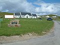
Capnagower (community center)
Clare Island
Clare Island.

Clare Island.


literature
- Anne Chambers: Granuaile - The Life and Times of Grace O'Malley. Wolfhound Press, Dublin 1979, ISBN 0-905473-31-0
Web links
Individual evidence
- ↑ Table No. 11 Population of inhabited Islands off the coast, 2006 and 2011 . In: Central Statistics Office (Ed.): Population Classified by area . Dublin 2012, pp. 132-133 ( PDF file; 3.64 MB ( memento of October 10, 2012 in the Internet Archive ))