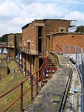
Coalhouse Fort
Coulhouse Fort is a British fortification located near the town of Tilbury ( Thurrock , Essex ) on the banks of the Thames , 3.7 km downstream from Tilbury Fort . Directly opposite, on the right bank of the river, about 1.5 km away is the Cliffe Fort .
history
The first defunct fort was once the site of an artillery battery. In the 1860s, at the instigation of the Royal Commission on the Defense of the United Kingdom, reconstruction for coastal protection purposes and as part of a defense network in front of the British capital, London . The fort was completed in 1874.
During the Second World War , Coalhouse Fort was equipped with magnetic field monitoring devices for ships in order to take action against mines. The facility was manned by Wrens , the Royal Women's Navy Service, and civil engineers. The crew was obliged to maintain strict secrecy because of the technology used. Today there is a museum in the premises with exhibits about the First and Second World War. Guided tours through the fortress are possible.
construction
Coalhouse Fort lies directly on the banks of the Thames, it is only separated from the river by a narrow piece of land and a "damp ditch". Apart from a well, a cistern and a tunnel that goes under the outer walls, there are no underground building structures in the fort. One problem is the location: due to its proximity to the river and the swampy subsoil, the fort was and is threatened by flooding. The rampart wall facing the Thames is curved in an arc; inland, Coalhouse Fort consists of straight brickwork around an irregular courtyard with a bastion on the northwest corner.
Web links
Coordinates: 51 ° 27 '53.7 " N , 0 ° 25' 58" E

