Tilbury Fort

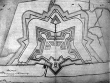
Tilbury Fort is a pentagonal fortress located on the north bank of the Thames east of London in the county of Essex , which in its present form was built on the site of a D-shaped fortification built in 1539 under Henry VIII under Bernard de Gromme (who also expanded the Plymouth Citadel ) was built from 1670 to 1683.
history
Henry VIII's fortifications were built on the site of an earlier hermitage. The construction of the existing fortress was caused by anticipated attacks by a Dutch-French fleet. Bernard de Gromme designed the new fort on behalf of King Charles II. The fortress never achieved practical military importance, but was still used to defend London during the World Wars. In the First World War, for example, a German zeppelin was shot down from her . The facility was bombed during World War II . After ceasing military use in 1950, it is now looked after by English Heritage .
investment
The fortress, which is leaned against the banks of the Thames in the south, has the shape of a pentagon with star-shaped bastions , brick-fortified earth walls and a double moat, as well as the possibility of flooding the surrounding marshland . Access is via (reconstructed) drawbridges. Inside there is a paved parade yard. The Water Gate with arms trophies in the gable faces the Thames .
The Coalhouse Fort is 3.7 km down the river .
literature
- Peter Sager : East England . DuMont art travel guide. Cologne 1990: DuMont Buchverlag. P. 98 ff, with historical floor plan, ISBN 3-7701-1713-1 .
- Paul Pattison: Tilbury Fort . English Heritage, 2004.
Individual evidence
- ↑ Sager p. 101
Web links
Coordinates: 51 ° 27 ′ 10 ″ N , 0 ° 22 ′ 29 ″ E

