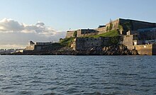
Plymouth Citadel
The Citadel of Plymouth ( English Royal Citadel ) is a fortress in the county of Devon in Great Britain . The citadel is on a hill above the city of Plymouth .
location
The Citadel is located on the east end of The Hoe , a limestone cliff up to 25 m high at the north end of Plymouth Sound . From there, both the city of Plymouth and the entrance to the port of Sutton Pool and the Cattewater , the mouth of the River Plym , could be dominated.
history
On the strategically important hill, a chapel called St Katherine upon the Hoe was consecrated in 1370 , which, due to its location, also served as a navigation mark . Presumably a castle consisting of two towers was also built on the hill in the 14th century. In light of the threats posed by the Spanish fleet, a new coastal fortification was built on the cliff from 1592 to 1598. In place of this fort, Charles II, under the influence of the Anglo-Dutch War from 1665 to 1675, had the citadel built according to a design by Bernard de Gromme . With its dominant position over the city, it served not only to defend the important port, but also to control Plymouth, which had sided with Parliament during the Civil War .
After the landing of Wilhelm III. in November 1688 it was the first English fortress to support the Glorious Revolution . The fortress has been renewed and expanded several times. Around 1750 it was armed with 113 cannons. In 1888 the outer works were sold to the city of Plymouth, which backfilled the trench and had part of the outer works demolished to create the Madeira Road and other roads there.
The fortress was never involved in acts of war , with the exception of the Plymouth Blitz air raids , in which it suffered little damage. Since 1910 it has served as a training facility for artillery units and is still the location of a unit of the Royal Artillery today . The historic buildings of the fortress are managed by English Heritage and can be visited twice a week as part of a guided tour.
investment
The fort, built towards the end of the 16th century, had two bastions on a triangular floor plan to the north and west to protect it against attacks from the land. The walls of this complex were partially included in the construction of the new citadel, but can still be seen. The citadel has six bastions and a half bastion, the up to 21 m high earthworks clad with local limestone enclose an area of about 280 × 270 m. The main gate, built in 1670 based on a design by Thomas Fitch in the style of a baroque triumphal gate, is secured by a ravelin in front of it , which is hinted at as an elevation. Another, somewhat Kleiner's Gate is located in the neighboring north-western curtain wall , the Ravelin also can not recognize before. In the north and west, the citadel is still surrounded by a dry moat with a glacis in front , on the other sides the moat was filled in or torn down with the originally existing counter- screech. In the southeast of the facility there is a small harbor basin, with whose help the fortress could have been supplied in the event of a siege, as well as the Lower Fort . Some of this facility dates back to the 16th century, including the Fisher’s Nose log cabin built in the first half of the 16th century .
The buildings inside the fortress enclose a wide parade ground . The guard house, a magazine and the Governor’s and Lieutenant-Governor’s House date from the 17th century . At the edge of the square there is a lead statue of George II from 1728. The medieval chapel had to give way to the construction of the citadel and was replaced by the current garrison church from 1677 to 1688 . In 1845 the church was expanded.
Web links
- English Heritage: Royal Citadel, Plymouth
- The Encyclopaedia of Plymouth History: Royal Citadel ( Memento of September 28, 2013 in the Internet Archive )
- The National Heritage List for England: Royal Citadel, Plymouth
Individual evidence
- ^ Plymouth Castle. Retrieved March 30, 2013 .
- ^ The Citadel, Plymouth. Retrieved March 30, 2013 .
- ^ The Encyclopaedia of Plymouth History: Garrison Church of St Katherine the Virgin upon the Hoe. Archived from the original on January 29, 2013 ; accessed on March 30, 2013 .
Coordinates: 50 ° 21 '52.9 " N , 4 ° 8' 15.3" W.


