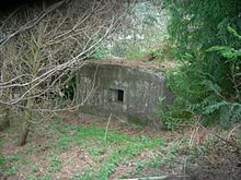
Coquet stop line
The Coquet Stop Line was a British during the Second World War created line of defense . This defense system begins near the small town of Amble in Northumberland and runs along the Coquet River , which is also the name of the position. It was erected against a potential German landing, which, unlike Operation Sea Lion, which was actually planned , would have threatened north-east England from the north. The strategic goal of the defense line was to slow down a possible German advance in order to gain time for manning the Tyne Stop Line 30 km south . The position consisted of so-called pillbox bunkers.
Location of well-known bunkers on the Coquet Stop line
| ID | location | Coordinates | Remarks |
|---|---|---|---|
| P454 | West Thirston | Location | |
| P305 | Catheugh Plantation | Location | |
| P306 | Weldon Bridge | Location | |
| P307 | Brinkheugh | Location | |
| P308 | Middleheugh, Brinkburn Priory | Location | |
| P309 | Pauperhaugh | Location | |
| P310 | Brinkburn Station | Location | |
| P311 | Rothbury (school grounds) | tore off | |
| P312 | Cartington near Rothbury | Location | This bunker is on Garleigh Moor, not in Cartington itself. |
| P313 | Carterside near Rothbury | Location | |
| P314 | Newtown | Location | |
| P315 | Ryehill | Location | |
| P318 | Little Tosson | Location | |
| P319 | Bickerton | Location | |
| P320 | Bickerton | Location | |
| P321 | Hepple | Location | |
| P322 | Hepple | Location | |
| P323 | Harehaugh | ||
| P --- | Brainshaugh (north of the river) | Location | |
| P583 | Morwick | Location | |
| P --- | Rothbury | Location |
