
Cornet skirt
| Cornet Rock (Castle Rock) |
||
|---|---|---|
 |
||
| Waters | English Channel | |
| Archipelago | Channel Islands | |
| Geographical location | 49 ° 27 '10.8 " N , 2 ° 31' 34.8" W | |
|
||
| length | 175 m | |
| width | 130 m | |
| surface | 2 ha | |
| main place | Castle Cornet | |
 within Saint Peter Port (white) |
||

Cornet Rock or Castle Rock is a small offshore island of Guernsey , Channel Island . The famous Castle Cornet is on the island . The name of the castle is much better known and is also used colloquially for the island.
history
The former tidal island was fortified with a castle for the first time between 1206 and 1256 in the course of the division of the Duchy of Normandy in 1204. In 1338 the island was besieged and conquered by a French force, and the English garrison was massacred.
The castle complex was reinforced between 1545 and 1548. In his book The Building of Castle Cornet John Le Patourel writes that in 1566 a quarry in "Creavissham" ( i.e. Crevichon , a small island off Jethou ) supplied material for the castle.
Castle Cornet served as the governor's seat of Guernsey until 1672, when the tower block was completely destroyed by lightning.
Cornet Rock was linked to mainland Guernsey by a breakwater after the Napoleonic Wars in 1859. A pond for model yachts was created at the breakwater in 1887 on the occasion of the throne jubilee of Queen Victoria , which served as a base for flying boats during the First World War.
During World War II, Cornet Rock was occupied by a small force of German soldiers. The Crown gave the island and castle to the people of Guernsey in 1947.
geography
Cornet Rock is located in the southeast of the man-made port of Saint Peter Port on Guernsey and belongs to the parish of the same name ( parish ) Saint Peter Port. Since 1859 the island (northern tip) through the 500 meter long is Pier Castle Pier connected to the mainland of Guernsey and today marks the southeastern point of the expanded port facilities of Saint Peter Port. Similarly as an extension of the pier extends Castle Breakwater (engl. Breakwater = breakwater further 150 meters) to the east. Castle Pier and Castle Breakwater form the southern boundary of the port of Saint Peter Port.
Attractions
Most of the island's area is dominated by the Castle Cornet facilities, which include the following facilities:
- The Story of Castle Cornet
- Maritime Museum
- 201 Squadron RAF Museum
- Royal Guernsey Light Infantry Museum
- Royal Guernsey Militia Museum
There is also a restaurant. Open-air theater performances are held in summer. It is also known to fire the Castle Cornet Noonday Gun .
Photo gallery

Engraving from 1672 shows the residential tower, which was destroyed by lightning that same year

Drawing from 1814 (before the connection to Guernsey)
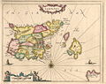
historical map of Guernsey with Castle Cornet (before the connection to Guernsey)

The French map from 1757 shows the castle and island as Chateau Cornet , the city as St. Pierre and the main island as Isle de Grenesey .

Construction of the pier to the island
Photo from the 1850s
Castle Cornet from the north. On the left (east) the pier extends a little out into the sea. The main island of Guernsey can be seen on the right.

South side of Cornet Rock

North side with a view of the harbor

Part of the Castle Cornet

Firing the "Castle Cornet Noonday Gun"


Web links
literature
- Ferdinand Brock Tupper: The Chronicles of Castle Cornet , Guernsey, 1851
- John Le Patourel: The Building of Castle Cornet