Coromandel Range
| Coromandel Range | ||
|---|---|---|
|
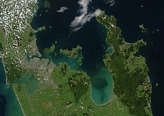
Image from a NASA earth observation satellite from October 23, 2002 with the city of Auckland (left), the Hauraki Gulf (center) and the Coromandel Peninsula (right). |
||
| Highest peak | Kaitarakihi ( 852 m ) | |
| location | North Island New Zealand | |
|
|
||
| Coordinates | 37 ° 0 ′ S , 175 ° 40 ′ E | |
The Coromandel Range is a mountain range of rugged mountains that stretches almost the entire length of the Coromandel Peninsula on the North Island of New Zealand .
geography
The Coromandel Range extends over 85 km in a north-south extension almost over the entire peninsula of the Coromandel Peninsula. Rising steeply on the west coast, the mountain range increasingly flattens out to the east. At its widest extent, it measures around 25 km. The highest point of the Coromandel Range is the Kaitarakihi, 13 km east of Thamse , at 852 m .
The Coromandel Range is part of a network of different heights and mountain ranges that stretch like a backbone over the North Island. North of the Coromandel Range, the Moehau Range runs to the northern end of the peninsula. The highest point there is the Moehau with 892 m . The north of the peninsula in the Hauraki Gulf island lying Great Barrier Iceland forms as the northern continuation of these mountains. At the southern end of the Coromandel Range, the Karangahake Gorge separates the mountain range from the Kaimai Range, which continues to the south .
Origin of name
The name Coromandel is borrowed from a ship of the same name that docked in Coromandel Harbor, a little south of the town of Coromandel, in 1820 to load wood from the kauri trees. On board was the missionary Samuel Marsden , founder of the first Christian mission in New Zealand. It can be assumed that Marsden or someone close to him named the peninsula and the place that way. The mountain range was later named after the peninsula as the dominant part of the peninsula.
description
When the weather permits, the Coromandel Range forms a weather divide between the east and west of the peninsula; due to the relatively steep rise of the mountains compared to the sea surface, the mountain peaks are often covered in clouds despite their comparatively low altitude, while the peninsula can be viewed in the most beautiful sunshine the coast can circumnavigate.
The four cross connections between the east and west side of the peninsula over the mountains offer a view of an interesting and pristine mountain landscape. Despite intensive logging of the Kauri forests at the beginning of the 19th century, there are still some beautiful Kauri forest areas well hidden in the mountains .
literature
- Helga Neubauer: Coromandel . In: The New Zealand Book . 1st edition. NZ Visitor Publications, Nelson 2003, ISBN 1-877339-00-8 , pp. 225-226 .
- James Cecil Schofield: Coromandel Range . In: Alexander Hare McLintock (Ed.): An Encyclopaedia of New Zealand . Wellington 1966 ( online [accessed January 4, 2015]).
Web links
- The Coromandel. Destination Coromandel, accessed on January 4, 2016 (English).
Individual evidence
- ↑ a b Topographic maps. Information New Zealand (LINZ), accessed on January 4, 2016 (English).
- ^ Neubauer: Coromandel . In: The New Zealand Book . 2003, p. 226 .

