Hauraki Gulf
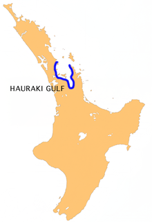
The Hauraki Gulf , in the language of the Māori Tīkapa Moana called, is a large bay in the northwest of the North Island of New Zealand, with access to the Pacific Ocean .
geography
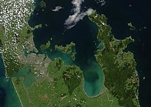
The Hauraki Gulf is east of Auckland between Northland and Auckland on the western side and the Coromandel Peninsula on the eastern side. To the south the bay connects to the Firth of Thames and is bordered in the north by the two islands Little Barrier Island and Great Barrier Island . The bay has access to the Pacific Ocean via the three waterways Jellicoe Channel , between Northland and Little Barrier Island , Craddock Channel , between Little Barrier Island and Great Barrier Island , and Colville Channel , between Great Barrier Island and the Coromandel Peninsula .
The largest islands that lie within the gulf are Kawau Island , east of Warkworth , and Rangitoto Island , Motutapu Island , Waiheke Island, and Ponui Island , east of Auckland .
Name and origin of name
One possible explanation for the meaning of the name Hauraki is the word composition of hau and raki . Since hau in the language of Māori u. a. Wind means and raki north, the name could be translated as "northern wind".
The other names that the golf has for the Māori are Tikapa Moana and Te Moananui a Toi . They have their origins in Māori mythology , in which the arawa waka (canoe) went ashore in the sheltered bay of the Hauraki Gulf on the coast of the Coromandel Peninsula and its crew settled there.
Emergence

The Hauraki Gulf was formed after the last ice age around 10,000 years ago when the ice masses melted and the sea level rose as a result. The great plain that lay between today's islands was flooded and so became part of the ocean. The result was a shallow body of water with numerous bays, headlands and natural harbors. The coastal landscape was shaped by estuaries, wetlands and a lush coastal forest landscape.
Hauraki Gulf Marine Park
The Hauraki Gulf Marine Park covers 13,900 km² a much larger area than the Hauraki Gulf . The purpose of establishing the marine reserve in 2000 was to protect the unique ecological sea area around the Hauraki Gulf from the negative influences of the Auckland conurbation and from the influences of agriculture and livestock.
The water catchment areas of the Hauraki Gulf became part of the protection zone. Since, in addition to the Auckland conurbation, the intensive cultivation of the Hauraki Plains also has an impact on the marine ecosystem of the Gulf, the protection zone was also extended to the large agricultural plains adjacent to the south, which is also part of the Gulf's water catchment area. The Coromandel Peninsula , plus the eastern sea area off its coast, was also included in the protection zone.
Nevertheless, manure and sewage continued to enter the Gulf, whose coastal region is considered to be the fastest growing settlement area in New Zealand. Fishing in the marine reserve was still allowed. There was a great decline in biodiversity . By 2019, the population of some important marine animals decreased dramatically, the formerly predominant kelp forest disappearing.
literature
- Hauraki Gulf Forum (Ed.): Covering the Gulf . Giving Effect to the Hauraki Gulf Marine Park Act through Policies and Plans . Auckland 2009, ISBN 978-1-877528-54-5 (English).
Web links
- James Cecil Schofield : Hauraki Gulf . In: An Encyclopaedia of New Zealand . Alexander Hare McLintock , April 22, 2009, accessed April 17, 2016 .
Individual evidence
- ↑ a b c Topo250 maps . Land Information New Zealand , accessed April 17, 2016 .
- ↑ James Cecil Schofield : Hauraki Gulf . In: An Encyclopaedia of New Zealand . Alexander Hare McLintock , April 22, 2009, accessed April 17, 2016 .
- ^ Department of Conservation (Ed.): Hauraki Gulf Marine Park . Auckland 2010, ISBN 978-0-478-14732-2 , pp. 1 (English).
- ^ Hauraki Gulf Forum (Ed.): Covering the Gulf . 2009, p. 14 .
- ^ Hauraki Gulf Marine Park - Catchment anld TLA bounderies . Auckland Council , December 12, 2011, accessed April 17, 2016 .
- ^ Kate Evans: 'We used to be leaders': the collapse of New Zealand's landmark ocean park. In: theguardian.com . March 11, 2020, accessed on March 11, 2020.
Coordinates: 36 ° 21 ′ S , 175 ° 2 ′ E
