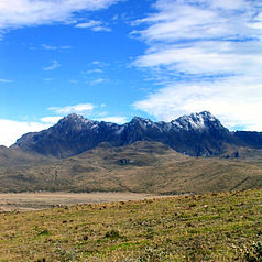
Cotopaxi National Park
| Cotopaxi National Park | ||
|---|---|---|
| Cotopaxi | ||
|
|
||
| Location: | Ecuador | |
| Surface: | 322.55 km² | |
| Founding: | August 11, 1975 | |
| Rumiñahui | ||
The Cotopaxi National Park ( Spanish Parque Nacional Cotopaxi ) was designated on August 11, 1975 as one of the nine national parks of Ecuador . It is located on Cotopaxi , the second highest mountain in Ecuador, which is also the main attraction of the park, and about 40 km south of Quito . The park is located in the province of Cotopaxi and partly in Napo and Pichincha .
The scenic plain around the Cotopaxi is also part of the park. The animals found here are puma , Andean condor , llama , wild horse and other wild animals.
Other attractions include the volcano Rumiñahui that Limpiopungo Lagoon, the ruins of the former Inca fortress Pucara and that of Túpac Yupanqui , built in the 15th century Inca palace at the foot of Cotopaxi, which in the 17th century by members of a Catholic Augustinian Order in a Monastery has been rebuilt. It is currently a hotel, the Hacienda San Agustin de Callo.
The Cotopaxi National Park is 32,255 hectares in size and lies between 3399 m and 5897 m above sea level, the highest point being the summit of Cotopaxi.


