Cuba (Gera)
|
Cuba
City of Gera
Coordinates: 50 ° 53 ′ 10 ″ N , 12 ° 4 ′ 10 ″ E
|
|
|---|---|
| Height : | 190 m above sea level NN |
| Incorporation : | 1897 |
| Incorporated into: | Lower house |
| Postal code : | 07548 |
| Area code : | 0365 |
|
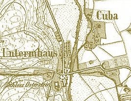
Location and extent of Cuba (around 1850)
|
|
|
Gera, Leibnizstrasse, corner of Cubaer Strasse
|
|
Cuba was a formerly independent place in the area of today's city of Gera in Thuringia .
location
The town center was located northeast of Osterstein Castle on the right bank of the White Elster , opposite the Untermhaus district . The geographic height of the place is 190 m above sea level. NN .
history
During the 19th century, Untermhaus quickly took on the appearance of a small town. In 1897 Cuba was incorporated into Untermhaus and with this in 1919 to Gera. The place name Cuba was no longer used, and the part of Untermhaus to the right of the Elster was also given the name Neu-Untermhaus . The names of the Cubaer Strasse (since 1919; previously Friedrichstrasse ) and the Cubabrücke over the Weisse Elster (since 1950; previously Elisenbrücke ) remind us of the place name Cuba .
Individual evidence
- ↑ Official topographic maps of Thuringia 1: 10,000. LK Altenburger Land, LK Greiz, district-free city of Gera . In: Thuringian Land Survey Office (Hrsg.): CD-ROM series Top10 . CD 5. Erfurt 1999.
- ↑ Siegfried Mues, The street names of the city of Gera from A to Z , Gera 2006, pp. 74–76.
- ^ Siegfried Mues, The street names of the city of Gera from A to Z , Gera 2006, p. 329.

