
Damsterdiep

| |||
Course of the Damsterdiep |
The Damsterdiep is a 28 km long canal in the Netherlands with the Zeehavenkanaal outside the Siels 34 km long , which connects the city of Groningen with Delfzijl on the Ems estuary . The name is derived from the generic term -dam (m) in the name of the city of Appingedam, which is located on the canal . The catchment area measures 367.43 km². Although located entirely in the Netherlands, it has also been given a German waterway code.
history
The oldest part, called Delf , was probably dug before the year 1000. The canal was initially subject to the tides and connected a natural low, now barely recognizable, called Fivel , which flowed northward into the Fivelbusen , which silted up in the 12th to 15th centuries , with the Ems below the Oosterwierum monastery .
A document from 1303 mentions three sluices at the Münung in the Ems and the place named after them Delfzijl for the first time.
There was a connection to Groningen even before today's straight canal section between Ten Post and the city was built around 1424 . The drainage of the area around Ten Boer has been significantly improved by the new dug canal . In the Wierumer Zijlboek (Sielbuch) around 1470, the entire canal is known as the Groninger Diep . The name Damsterdeep was probably used as early as 1425–1427 in the Chronicle of Johan van Lemego , but is only received in later texts.
The westernmost parts of Damsterdiep in Groningen between the Van Starkenborghkanaal and the Schuitendiep on the edge of the medieval old town are now a street. The outer part was filled in with the rubble of war-torn houses in 1951, the inner part gave way to an underground car park in 2007.

Damsterdiep near Delfzijl
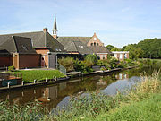
Damsterdiep in Garrelsweer
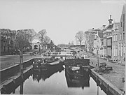
Binnen-Damsterdiep in Groningen 1886


Traffic route
From 1650 a line service with tow barges was operated on the Damsterdiep .
Since the Eems Canal was built between 1866 and 1876, Damsterdiep has only been of local importance as a traffic route. The Eemskanaal runs - in a straighter line - south of the Damsterdieps, more or less parallel.
Today the Damsterdiep is only used for recreational navigation with small boats, approved for a height of up to 1.50 m.
supporting documents
- ↑ Drawn GPS track Damsterdiep + Zeehavenkanaal
- ↑ Environment Lower Saxony: Area Directory Ems (PDF; 221 kB)
- ↑ "Damsterdeep" in old Groningen documents
- ↑ Leisure time shipping: Enkeltje Damsterdiep (12 km) (Dutch)
Coordinates: 53 ° 18 ' N , 6 ° 44' E