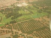
Agdal Gardens of Marrakech
The Agdal Gardens of Marrakech are the oldest preserved park in this Moroccan city. Since 1985, together with the old town of Marrakech and the Menara Garden, they have been on the UNESCO World Heritage List .
history
The gardens were laid out in 1157 under the Almohad ruler Idris I al-Ma'mun , their architect is probably al-Hajj Yaish (al-Ḥāǧǧ Yaʿīš) from the Gedmiwa tribe. The garden covers 500 hectares and was almost as big as Marrakech itself.
The first trees were planted in the 12th century; olive trees, oranges, grapevines, apricots and fragrant flowers have been proven. The orange plantations were closest to the basin, followed by olive trees, the wingert, pomegranates, figs, palms, walnuts and almonds.
The Almohad soldiers learned to swim in the basins before they crossed the Mediterranean to al-Andalus ; receptions were also held here.
After Fez was elevated to the seat of a royal seat, the Agdal was neglected. The Saadians (1517–1659) created an Agdal, which was called Rauḍ al-Masarra . It was probably located on the grounds of Dar al-Hana (Dār al-Hanāʾ) and had fountains. It contained pomegranates, olives, lemons, grapes and palms. The garden paths were lined with myrtles, roses, jasmine, black elder, evergreen trees, and wild roses. This garden has also been described by European travelers such as Thomas le Gendre and Adriaan Matham. The latter mentions 26,000 olive trees.
After the end of the Saadian dynasty, the residence was moved to Meknes and the garden fell into disrepair. Local tribes diverted the irrigation channels. In the silted up basin of al-bahr al-asghar (al-baḥr al-ʾaṣġar) a small town had emerged. In 1828/29 Mulai Abd ar-Rahman began to restore the garden, a project that his successors continued. In 1834 the residents of al-bahr al-asghar were expelled and the sand removed. Now olive trees, pomegranates, apples, grapes, almonds, walnuts, figs and oranges grew again in the garden. Boats plyed on the water basin. In the outer (barrani) Agdal there were workshops in which sugar and gunpowder were made. The actual pleasure gardens were in the center of the complex.
The current shape of the park and the surrounding walls date from the 19th century.
construction
Today, the Agdal Gardens, with their scattered pavilions, extend several kilometers south of the Royal Palace. In the south they touch the area around the palace Dar al-Machzan (Dār al-Maḫzan) .
The garden contains three water basins, the largest being the one in Dar al-Hana . It is 220 m long and can hold 200,000 m 3 of water. The water comes from Aghmât in the Atlas Mountains, about 30 km away . It is brought to the Ourika Wadi in an open channel called Tasoultant . Water from the khettaras and rainwater also fed the pools. Large carp live in the pools. On the bank of the largest water basin as-Sala stands the Dar al-Hana palace , from whose viewing terrace the peaks of the High Atlas can be seen.
planting
Pomegranate , orange and olive trees grow in the garden . The gardens have a more diverse vegetation than the Menara Garden.
Publicity
Parts of the gardens are open to the public on Fridays and Sundays.
Individual evidence
- ↑ UNESCO World Heritage Center: Medina of Marrakesh. Accessed August 21, 2017 .
- ↑ a b el Faïz, garden strategy , p. 98
- ↑ a b c el Faïz, garden strategy , p. 103
- ↑ el Faïz, garden strategy , p. 102
- ↑ el Faïz, garden strategy , p. 104
- ↑ el Faïz, garden strategy , p. 105
- ↑ a b Angelica Gray: The Gardens of Marrakech - in pictures. The Guardian, accessed June 10, 2014 .
Literature and web links
- Mohammed el Faïz: The garden strategy of the Almohad sultans and their successors (1157-1900) . In: Michel Conan (Ed.), Middle East Garden Traditions: Unity and Diversity. Questions, Methods and Resources in a multicultural perspective . Dumbarton Oaks Research Library and Collection. Washington DC, Harvard Press, 2007
- Entry in the UNESCO World Heritage List (English) (French)
Coordinates: 31 ° 36 ′ 22 " N , 7 ° 58 ′ 47" W.


