Daysland
| Daysland | ||
|---|---|---|
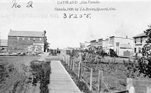
 Daysland in 1920 |
||
| Location in Alberta | ||
|
|
||
| State : |
|
|
| Province : | Alberta | |
| Municipal District: | Flagstaff County | |
| Coordinates : | 52 ° 52 ′ N , 112 ° 15 ′ W | |
| Height : | 710 m | |
| Area : | 1.75 km² | |
| Residents : | 818 (as of 2006) | |
| Population density : | 467.4 inhabitants / km² | |
| Time zone : | Mountain Time ( UTC − 7 ) | |
| Postal code : | T0B 1A0 | |
Daysland is a town in the Canadian province of Alberta in Flagstaff County , about 43 km east of Camrose . The village can be reached via Alberta Highway 13 and Alberta Highway 855 . Daysland has 818 inhabitants (as of 2006). Daysland has 333 households, which is an increase of 5% compared to 2001. The village has an area of 1.75 km², the population density is 467.5 / km².
sons and daughters of the town
- Matthew Spiller (born 1983), Canadian ice hockey player
