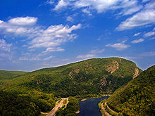
Delaware Water Gap National Recreation Area
The Delaware Water Gap (Delaware Gap National Recreation Area ) is a recreation area (Delaware Water Gap National Recreation Area ) on the east coast of the United States on the border between New Jersey and Pennsylvania . The Delaware River runs here through the northern foothills of the Appalachian Mountains .
The Delaware Water Gap National Recreation Area is a popular park in the wider area for rafting , canoeing , swimming , hiking, or fishing . Since the Delaware Water Gap has a fairly large black bear population, bear sightings are not uncommon.
The Red Dot Trail is a demanding National Park Service ( NPS ) hiking trail to the summit of Mount Tammany , from where you have extensive panoramic views of the entire area.
location
The Delaware separates the Northern Appalachians at the Delaware Water Gap into the Blue Mountains on the Pennsylvania side, and the Kittatinny Ridge in New Jersey. On the New Jersey side, the Delaware Water Gap has its highest point with Mount Tammany in the Worthington State Forest . On the Pennsylvania side, Mount Minsi is the highest point in the Water Gap. The Appalachian Trail runs along the Delaware Water Gap .
The Interstate 80 leads directly to the Water Gap along for a few miles on the Delaware and offers parking for hiking, canoeing and picnics.
Web links
- Delaware Water Gap website
