Devils Lake (Oregon)
| Devils Lake | ||
|---|---|---|

|
||
| Devils Lake and Lincoln City from the air | ||
| Geographical location | Lincoln County in Oregon (USA) | |
| Tributaries | Rock Creek, Thompson Creek | |
| Drain | D River | |
| Places on the shore | Lincoln City | |
| Data | ||
| Coordinates | 44 ° 59 '3 " N , 123 ° 59' 17" W | |
|
|
||
| Altitude above sea level | 4 m | |
| surface | 277 ha | |
| length | 4.8 km | |
| width | 600 m | |
| scope | 17.2 km | |
| Maximum depth | 6.4 m | |
| Middle deep | 2.6 m | |

|
||
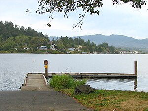
| Boat dock in Devils Lake State Recreation Area | ||
The Devils Lake is a natural lake in the US state of Oregon . The 277 acre lake is located east of the city of Lincoln City in Lincoln County . The shallow lake is a maximum of 6.4 meters deep, its average depth is 2.6 meters. Almost five kilometers long and an average of 600 meters wide, the lake stretches between the city of Lincoln City and the Oregon Coast Range with the Siuslaw National Forest . Main tributaries are Rock Creek at the southern end of the lake and Thompson Creek in the northeast of the lake, the outflow of the lake is the D River in the southwest. The D River is considered to be the shortest river in the world, as it flows into the Pacific after only 37 meters.
The name Devils Lake refers to Indian legends, according to which a monster lives in the lake, which also attacks people, including a canoe belonging to the Siletz chief , Fleetfoot . In the language of the Indians, the lake was called Neotsu . Today a district of Lincoln City at the north end of the lake is called that.
On the southern part of the lake is the Devils Lake State Recreation Area . The city of Delake donated part of the area to the state of Oregon in 1957, through acquisitions the area was expanded to 42 hectares by 1961. The state park consists of two parts, a campground on the west bank and a park area on the south bank of the lake. The campsite with 32 RV and over 50 tent sites is located on the west bank near the D River. It is the only campsite on the Oregon coast that is in the middle of a city. The pitches are located between coastal pines and alders and are separated from the lake by a wetland. A footpath leads from the campsite to the lake shore, where there is a boat ramp. The wetland is a habitat for many water birds such as great blue herons , cormorants , coots and ducks. The lake is winter quarters for numerous migratory birds, including bald eagles . The park area for day visitors is located on the south bank of the lake, where there is also a landing stage and a ramp as well as picnic tables and a bathing area. The lake is popular for fishing, but it also offers space for water skiing, kayaking, and other water sports.
literature
- Jan Bannan: Oregon State Parks. A complete Recreation Guide . 2nd Edition. Mountaineer Books, Seattle 2002, ISBN 978-0-89886-794-7 .
Web links
- About Devils Lake
- Devils Lake State Recreation Area website
- Devils Lake in the United States Geological Survey's Geographic Names Information System
Individual evidence
- ^ Devils Lake Water Improvement District. (No longer available online.) Archived from the original on May 14, 2011 ; Retrieved April 27, 2011 . Info: The archive link was inserted automatically and has not yet been checked. Please check the original and archive link according to the instructions and then remove this notice.
