Dinagat
| Municipality of Dinagat | ||
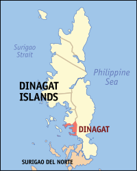
| Location of Dinagat in the Dinagat Islands province | ||
|---|---|---|

|
||
| Basic data | ||
| Region : | Caraga | |
| Province : | Dinagat Islands | |
| Barangays : | 12 | |
| District: | 1. District of Dinagat Islands | |
| PSGC : | 168503000 | |
| Income class : | 5th income bracket | |
| Households : | 1932 May 1, 2000 census
|
|
| Population : | 10,632 August 1, 2015 census
|
|
| Coordinates : | 9 ° 57 ′ N , 125 ° 36 ′ E | |
| Mayor : | Gwendoly B. Ecleo | |
| Geographical location in the Philippines | ||
|
|
||
Dinagat is a Filipino municipality in the Dinagat Islands province . It has 10,632 inhabitants (August 1, 2015 census).
Barangays
Dinagat is politically divided into twelve barangays .
- Bagumbayan
- Cab-ilan
- Cabayawan
- Cayetano
- Escolta (Pob.)
- Gomez
- Justiniana Edera
- Magsaysay
- Mauswagon (Pob.)
- New Mabuhay
- Wadas
- White Beach (Pob.)
