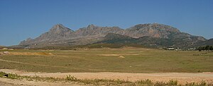
Djebel Zaghouan
| Djebel Zaghouan | ||
|---|---|---|
|
Djebel Zaghouan from the east |
||
| height | 1295 m | |
| location | Tunisia | |
| Coordinates | 36 ° 21 '7 " N , 10 ° 6' 43" E | |
|
|
||

The Djebel Zaghouan ( Arabic جبل زغوان) is a mountain range up to 1295 m high southwest of the Tunisian town of Zaghouan . It belongs to the dorsal ; large parts are designated as national parks.
history
The Djebel Zaghouan with its numerous springs was already important in Roman times - from here the approx. 90 km long main line of the aqueduct supplied the water after its destruction in 146 BC. BC rebuilt city of Carthage with fresh drinking water.
Ascent
It is possible to climb the wooded limestone mountain range, some of which are rich in gorges, but the scenic beauty of the area can also be explored on less demanding hikes. On the northern mountain slope - about 2 km from the city of Zaghouan - there is a large ancient spring sanctuary ( nymphaeum ).
Nature reserve
The entire area of the Djebel Zaghouan is under nature protection. The predominant trees are Aleppo pine and thuja . Birds of prey and foxes live in the forests and feed on small mammals, but wild boars and porcupines have also been sighted.

