
Dorsal (Tunisia)
| Dorsal | ||
|---|---|---|
 Zaghouan massif in the central part of the dorsal |
||
| Highest peak | Djebel Chambi ( 1544 m ) | |
| location | Tunisia | |
| part of | Tellatlas | |
|
||
| Coordinates | 36 ° 3 ' N , 9 ° 36' E | |


The Dorsal is the northeastern part of the Tell Atlas Mountains, which runs from Algeria in a northeastern direction to Cap Bon . Here you can find the highest mountains in Tunisia , such as the Djebel Chambi (1544 m) in the southwest or the Djebel Zaghouan (1295 m) in the northeast.
landscape
The multi-parted mountain ridge of the dorsal has a total length of about 220 kilometers. Since it does not form a continuous chain of mountains, it is divided into three geomorphological areas: These are the northern dorsal between the Moghrane plain and the Boukornine elevation west of Soliman , the central dorsal between the villages of Zaghouan and Maktar and the south-western dorsal foothills, which represent small separated mountain ridges. Some opinions assume that only the northern and central part can be called the dorsal. The allocation of the mountain ridge on the Cap Bon peninsula is also controversial, although it lies in the same direction as the mountain ridge.
Hilly farmland dominates between the rugged mountains. There is mainly grain cultivation; there are also olive plantations and vineyards . The loss of forest and bush vegetation due to centuries of human use has created increasing problems. This was already recognized during the French protectorate and the then Service des Eaux et Forêts began with extensive reforestation activities, which continue into modern times and enable forest management. Grassland spreads in the south of the dorsal.

Vineyards near Mornag with Djebel Ressas

Karst slopes on Djebel Mansour near El Fahs

Djebel Serj and Barrage Lakhmess

National park around the Djebel Boukornine


geology
The mountainous landscapes of the dorsal consist of limestone that are heavily shaped by transverse folds and transverse faults . The subsidence areas between the mountain structures are mostly Pliocene in age.
In some areas there are cart shapes that can be traced back to an intensive weathering period during the Pleistocene glacial periods and that are still subject to leaching during the annual period of brief snow cover. In places, soils similar to terra rossa have formed due to the weathering of limestone . Numerous rock grottos and smaller stalactite caves were washed out on the mountain flanks .
The predominant limestone comes from deposit cycles from the Lower Jurassic and the older Cretaceous period . It is largely reef limestone . The common terrain forms of these rock deposits are bizarre rocks with rugged rock walls and natural tower-like structures.
Weathering processes created several sedimentary basins in the subsidence zones during the younger Cretaceous and Tertiary periods . The foot regions of the mountain areas are mainly determined by Eocene (southern areas) and Lower Cretaceous (northern areas) marls .
Attractions
Apart from the charming landscape with its natural parks, there are a large number of ruins of ancient buildings or entire cities in the Dorsal. The ancient facilities of Mactaris and their museum area should be emphasized . At Zaghouane, an aqueduct from Roman times has been preserved for a long time. Also worth mentioning is the prehistoric necropolis with a large number of stone tombs ( dolmen ) on the Djebel Gorra .

Arch of Trajan in the forum of Mactaris
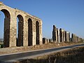
Roman aqueduct at Zaghouane

Mosaics in the Museum of Maktar

Djebel Gorra with the arch of Kouchbatia

Dolmen on the Djebel Gorra


traffic
Despite its attractiveness, the Dorsale is mostly off the classic tourist routes, especially if you leave the main traffic arteries.
The central area of the Dorsal is accessed with the regional road P 4, which, following the mountain direction, branches off from route P 3 in El Fahs in a southerly direction and leads via Siliana to Makthar.
See also
literature
- Horst Mensching: Tunisia (Scientific Country Customers, Volume 1.), Darmstadt (Scientific Book Society) 1974