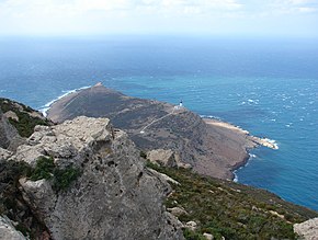
Cape Bon
| Cape Bon | ||
 View of the cape |
||
| Geographical location | ||
|
|
||
| Coordinates | 37 ° 4 ' N , 11 ° 3' E | |
| Waters 1 | Gulf of Tunis | |
| Waters 2 | Gulf of Hammamet | |
| length | 71 km | |
| width | 38 km | |
| surface | 2 000 km² | |
Cape Bon ( French Cap Bon ; Arabic الرأس الطيب, DMG ar-Raʾs aṭ-ṭayyib orرأس الدار / Raʾs ad-dār ) is a Tunisian peninsula that corresponds to the Nabeul Governorate in terms of its administrative boundaries .
Toponym
The Arabic name Ra's ad-Dar (literally means as much as head of the house ) has not been able to prevail against the name form ( Bono or Bona ) from the Romance-speaking area . The reason for this is seen in influences from the earlier Saracen rule in addition to the historical trade relations with Genoese seafarers.
location
Cape Bon, which gives the entire peninsula its name, is located in the extreme north of the peninsula. From there it is about 140 km to Sicily . South of it, on the east coast, are Kerkouane and Kelibia . Along the south coast one comes to Hammamet (Gulf of Hammamet) via Nabeul , two very popular places with tourists. From there you can get to Soliman (Gulf of Tunis) via Grombalia . To the north are the Zembra Islands. The highest point of the cape is the Djebel Korbous (419 m).
Economy and culture
The southern part of the peninsula in particular is used intensively for agriculture ( citrus fruits , olives , viticulture , grain ). A large part of these agricultural cultures with their irrigation methods can be traced back to the immigration of Muslim ( Moriscos ) and Jewish refugees from Andalusia , who emigrated in small groups during and after the Christian reconquest ( reconquista ) of the Iberian Peninsula and from 1609 by the Spanish King Philip III. were massively displaced. The entire region is shaped in a special way by Andalusian and partly also by Ottoman cultural influences. This applies to both the agricultural structures and most of the small-town settlements with their historical architecture.
history
In the 5th century BC Greek colonists founded the city of Neapolis near Nabeul . Cape Bon is best known for the sea battle at Cape Bon (255 BC) and its importance in the vandal campaign of 468.
The Tunisian campaign ended here on May 12, 1943 with the surrender of 232,000 German and Italian soldiers. The German population reacted in horror to this further defeat after Stalingrad and spoke behind closed doors of a "Tunisgrad".
Landscapes
literature
- Horst Mensching: Tunisia (Scientific Country Customers, Volume 1.), Scientific Book Society, Darmstadt 1979, ISBN 3-534-02862-7 .
Web links
Individual evidence
- ↑ Mensching: Tunisia p. 130 (based on the dissertation by H. Achenbach (1963), The Cape Bon Peninsula - Structural Analysis of a Mediterranean Cultural Landscape in Tunisia)
- ↑ Mensching: Tunisia pp. 57, 134
- ↑ Volker Issmer: Denazified as a fellow traveler (category IV). AT Edition, Zurich 2001, p. 278, ISBN 3-89781-007-7


