Kelibia
| Kelibia |
||
|---|---|---|
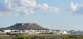
| Kelibia - fortress hill and city | ||
| administration | ||
| Country |
|
|
| Governorate | Nabeul | |
| Post Code | 8090 | |
| Demographics | ||
| population | 58,491 pop (2014) | |
| Population density | 457 inhabitants / km² | |
| geography | ||
| height | 10 m | |
| surface | 128 km² | |
|
|
||
| Coordinates | 36 ° 51 ′ N , 11 ° 5 ′ E | |

Kelibia ( Arabic قليبية) is a coastal city with around 45,000 and a delegation with around 60,000 inhabitants in northeastern Tunisia . A titular bishopric of the Roman Catholic Church is named after her.
location
The port city of Kelibia is located in the northeast of the Cape Bon peninsula and is about 110 km (driving distance) from Tunis . Kelibia is the third largest city in the Nabeul Governorate after Nabeul (approx. 62 km southwest) and Hammamet (approx. 77 km southwest).
climate
The temperatures in Kelibia are rather moderate due to the proximity to the sea; Rain falls mainly from January to March.
economy
Kelibia is the administrative headquarters of a delegation and is also an important fishing port with an annual volume of around 15,000 tonnes, which accounts for around 15% of Tunisian fishing . Thanks to its beaches, especially that of La Mansoura , Kelibia is a popular tourist destination. A fruity and dry muscat wine is also produced in the Kelibia area .
history
Kelibia goes back to the Phoenician or Carthaginian control settlement Aspis . During the First Punic War , the city was under siege in 255 BC. Captured by the Romans and renamed Clupea or Clypia . Conquered by Byzantium in the 6th century AD , it came under Islamic influence from the 7th century and under Ottoman influence in the 17th century .
Attractions
- Traces have already been discovered on the castle hill from Phoenician and Roman times. Today's fort towering over the city (also known as the ' citadel ') originally dates from the late Roman-Byzantine period, but was later expanded and partially renewed by the Ottomans by the Zirids and Hafsids , who used it as a fortified monastery ( Ribat ) . The almost trapezoidal layout is surrounded by angular defense towers . During excavations, the structures of an Islamic prayer room were uncovered. On a clear day you can see the island of Pantelleria , about 60 km to the east and belonging to Italy .
- A little outside the city, an early Christian baptistery in quadrilateral form with exceptionally well-preserved mosaic decorations was discovered; it is now one of the treasures of the Bardo Museum in Tunis.
- The Phoenician archaeological site of Kerkouane, recognized by UNESCO as a World Heritage Site , is located about 12 km to the north.
Town twinning
-
 Almuñécar (since 1986)
 -
 Pantelleria (since 1993)
 -
 Marsala (since 2003)
Personalities
- Mehdi Ben Dhifallah (* 1983), football player
Web links
- Kelibia - photos + information
- Kelibia Fort - photos + information (part 1)
- Kelibia Fort - photos + information (part 2)
- Kelibia Fort - aerial view + brief information (English)


