Castine
| Castine | ||
|---|---|---|
 Maine Maritime Academy |
||
| Location in Maine | ||
|
|
||
| Basic data | ||
| Foundation : | 1796 | |
| State : | United States | |
| State : | Maine | |
| County : | Hancock County | |
| Coordinates : | 44 ° 25 ′ N , 68 ° 49 ′ W | |
| Time zone : | Eastern ( UTC − 5 / −4 ) | |
| Residents : | 1,366 (as of 2010) | |
| Population density : | 67.6 inhabitants per km 2 | |
| Area : | 51.8 km 2 (approx. 20 mi 2 ) of which 20.2 km 2 (approx. 8 mi 2 ) is land |
|
| Height : | 10 m | |
| Postcodes : | 04420, 04421 | |
| Area code : | +1 207 | |
| FIPS : | 23-11265 | |
| GNIS ID : | 0582396 | |
| Website : | www.castine.me.us | |
Castine is a town in Hancock County in the state of Maine in the United States . In 2010 there were 1,366 inhabitants in 380 households on an area of 51.8 km².
geography
According to the United States Census Bureau , Castine has a total area of 51.8 km², of which 20.2 km² is land and 31.6 km² consists of water .
Geographical location
Castine is located at the mouth of the Bagaduce River on a headland in Penobscot Bay on the Atlantic Ocean , in the southwest of Hancock County. Several smaller lakes are scattered over the area of the town. The surface is flat, without any significant elevations.
Neighboring communities
All distances are given as straight lines between the official coordinates of the places from the 2010 census.
- North: Penobscot , 7.7 miles
- East: Brooksville , 4 miles
- Southwest: Islesboro , Waldo County , 7.5 mi
- West: Belfast , Waldo County, 14 mi
- Northwest: Searsport , Waldo County, 8 mi
City structure
There are three settlement areas in Castine : Castine , North Castine and West Castine .
climate
The mean mean temperature in Castine ranges from −6.1 ° C (21 ° Fahrenheit ) in January to 20.6 ° C (69 ° Fahrenheit) in July. This means that the place is around 6 degrees cooler than the long-term average in the USA. The snowfalls between October and May are up to two and a half meters, more than twice as high as the average snow depth in the USA; the daily sunshine duration is at the lower end of the range in the USA.
history
Castine is one of the oldest communities in North America . Since the early 16th century, Castine has been continuously settled.
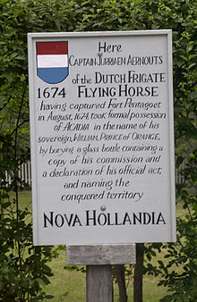
The French explorer Samuel de Champlain landed on the peninsula for the first time in 1604. In 1613 France set up a trading post there and named it Fort Pentagouet . After the Peace of Breda in 1667, Castine and the surrounding area were given to the French. A French officer named Jean-Vincent d'Abbadie de Saint-Castin was in command there, and the place is probably named after him.
Castine was occupied twice by the Netherlands , in 1674 and 1676. In 1676 they completely destroyed the place.
In 1779 it was rebuilt by the British . The Americans then tried in vain to wrest it from the British. After the peace of Paris and the associated definition of the borders, Castine fell to the United States
In the British-American War of 1812, Castine was an American garrison town. However, the place could not be held against the British overwhelming power and so came back into British hands in 1814. They vacated the area a year later and Castine is still part of the United States. In the following years Castine developed into an up-and-coming port. Shipyards were established and trade also flourished. At times hundreds of ships anchored in the port. With the civil war and the declining interest in sailing ships, Castine's heyday ended.
Population development
| Census Results - Town of Castine, Maine | ||||||||||
|---|---|---|---|---|---|---|---|---|---|---|
| year | 1800 | 1810 | 1820 | 1830 | 1840 | 1850 | 1860 | 1870 | 1880 | 1890 |
| Residents | 665 | 1036 | 975 | 1148 | 1188 | 1260 | 1357 | 1303 | 1215 | 987 |
| year | 1900 | 1910 | 1920 | 1930 | 1940 | 1950 | 1960 | 1970 | 1980 | 1990 |
| Residents | 925 | 933 | 743 | 726 | 662 | 793 | 824 | 1080 | 1304 | 1161 |
| year | 2000 | 2010 | 2020 | 2030 | 2040 | 2050 | 2060 | 2070 | 2080 | 2090 |
| Residents | 1343 | 1366 | ||||||||
Culture and sights
Buildings
In Castine, two districts and a number of buildings and a ship have been listed and listed on the National Register of Historic Places :
- As a district:
- Castine Historic District , recorded 1973, register no. 73000240
- Off-the-Neck Historic District , recorded in 1986, register no. 86002442
- As a building:
- Cate House , recorded 1970, register no. 70000040
- Fort George (Maine) Fort George , recorded 1969, register no. 69000007
- John Perkins House , recorded 1969, register no. 69000019
- As a National Historic Landmark :
- The Pentagoet Archeological District (an archaeological site where the former French Fort Pentagoet stood), recorded in 1993, register no. 93000603
Economy and Infrastructure
traffic
The Maine State Route 166 and 166A extend along the coastline of Castine.
Public facilities
There are no medical facilities or hospitals in Castine. The closest are in Belfast.
The Witherle Memorial Library is located on School Street in Castine. It emerged from a private library founded in 1801, which was taken over by the town in 1827.
education
Castine belongs to School Union 93 with Blue Hill, Brooksville, Penobscot and Surry . In Castine, the Castine School Department is responsible for school education.
In Castine is the Adams School with classes from pre-kindergarten through 8th grade. Middle and high school is offered through the School Union.
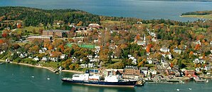
The Maine Maritime Academy is based in Castine. About 900 students are enrolled at this college.
Personalities
Personalities who have worked on site
- Jurriaen Aernoutsz captured Fort Pentagouet and the area for the Dutch crown in 1674
- Jean-Vincent d'Abbadie de Saint-Castin (1652–1707), French officer and Sagamore of the Penobscot, lived in Fort Pentagouet. Castine was named after him
- Hezekiah Williams (1798-1856), politician
- Lieutenant General John Moor British officer and military reformer. He fought at Fort George in 1779.
- Brigade General Francis McLean , British officer and commanding officer of Fort George 1779.
Web links
Individual evidence
- ^ Castine in the United States Geological Survey's Geographic Names Information System , accessed May 15, 2018
- ↑ Maine 2010 Census Results ; official publication of the Census Authority, (English; PDF; 32.5 MB)
- ↑ Coordinates of the locations of the Census Authority 2010
- ^ Castine, Hancock County | Maine Genealogy. In: mainegenealogy.net. Retrieved May 15, 2018 .
- ↑ a b Castine, Maine (ME 04421) profile: population, maps, real estate, averages, homes, statistics, relocation, travel, jobs, hospitals, schools, crime, moving, houses, news, sex offenders. In: city-data.com. www.city-data.com, accessed on May 15, 2018 (English).
- ↑ Population 1800–2010 according to census results
- ↑ Witherle Memorial Library, Castine Public Library. In: me.us. www.witherle.lib.me.us, accessed May 15, 2018 (British English).
- ^ About School Union 93. In: google.com. sites.google.com, accessed March 9, 2019 .


