
Zaghouan Aqueduct
Coordinates: 36 ° 36 ′ 58 ″ N , 10 ° 8 ′ 3 ″ E
| Zaghouan Aqueduct | ||
|---|---|---|
 |
||
| place | Destination Carthage ( Tunis ) | |
| construction | aqueduct | |
| overall length | 132 km | |
| completion | 1st half of the 2nd century AD | |
| Status | partially restored | |
| location | ||
|
||

The Aqueduct of Zaghouan or Aqueduct of Carthage is an ancient Roman aqueduct that supplied water to the North African city of Carthage . Fed by the springs on Djebel Zaghouan south of the small town of Zaghouan , it was one of the longest aqueducts of the Romans with a total length of 132 km .
Dating
The construction of the aqueduct is not clearly dated. On the one hand, a visit by the Emperor Hadrian in 128, with which a five-year dry season is said to have ended, gives clues . The lack of water that came with the drought probably meant that people no longer wanted to be dependent on rain alone. A second event is the inauguration of the Antoninus-Pius-Thermen 162 in Carthage. This bathing facility the size of the imperial baths in Rome required a constant water supply that could no longer be covered by rain alone.
The sources
.jpg)
The aqueduct is fed by several sources that were connected at different times.
Main source
The main source is near the village of Zaghouan on the northern slope of the Djebel Zaghouan, a mountain range about 60 km south of Carthage. A spring sanctuary ( nymphaeum ) was built over the spring in Roman times , which developed into the most important in ancient North Africa.
The sanctuary is located on an artificial terrace. Opened to the north and closed in a semicircle in the southern part, a square was enclosed by an approximately 4 m wide colonnade. In the center of the colonnades was the cella , under which the main spring rises . The remains of the statues found in the side niches are now in the Bardo Museum in Tunis .
The outer wall had a core made of Opus Caementitium and was clad with roughly embossed limestone blocks. The wall facing the square was divided into 26 areas by half-columns. In every second there was a niche for statues, but these are no longer preserved. Opposite each half column there was a whole column over which a groin vault spanned. The vault was made of porous travertine , which was clad with marble. The pillars were made of sandstone. The outside of the vault was sealed with waterproof Opus signinum and left without any further protection. The floor of the portico was covered with a mosaic. The cella, as the most important part of the structure, was made of limestone covered with marble.
Five springs arise in the area of the spring sanctuary. These were left in their original, underground bed in the area of the artificial terrace and only combined in a basin below the terrace. The water then flowed from the basin into the pipe of the aqueduct. In addition to the task of collecting water, the basin also served to purify the water. Due to the presence of the water, impurities could settle on the bottom.
Second source
In the Severan period a second spring was connected to the aqueduct. This was in the Jouggar region. There was also a spring sanctuary above this spring, but it never reached the importance of that of Zaghouan.
The water pipe


Technical specifications
The Carthage aqueduct is a masterpiece of Roman architecture. On the stretch from Zaghouan to Carthage, it overcomes a difference in altitude of just 264 m in just over 90 km, which results in an average gradient of 0.3%. However, in the first 6 km to Moghrane, 130 m are already overcome. So the remaining gradient to Carthage is 0.15% on average. The later pipeline from Djebel Djouggar flows into Moghrane and is another 33 km long. Overall, the aqueduct with all secondary lines has a length of 132 km and is therefore one of the longest in the Roman Empire.
The pipeline delivered between 200 and 370 liters of water per second, which resulted in between 17 and 32 million liters per day. The flow rate was between 3.5 and 5.5 km per hour, depending on the gradient. So the water took about 1.5 to 2 days from Zaghouan to Carthage.
course
The water pipe was built in such a way that it had a constant, if not even, gradient so that the water could overcome the route without further support. In order to have as little work as possible, the line was laid where possible on or just below the surface of the earth. Since one wanted to avoid unnecessary loss of height, the line followed the curve of the hills. However, it was not possible to set up the line on the ground in three levels. This is how impressive arcades were created . They were:
- In the Oued Miliane plain near Oudna and Mohamedia: 5 km. In addition, there was an approximately 125 m wide bridge over the Miliane river from a double row of arcades with a height of 33 m. The bridge was demolished in 1859 while a new bridge was being built to reuse the stones.
- At Oued Ellil: 2 km on up to 20 m high arcades
- In the plains of La Soukra, between El Ariana and Carthage: 10 km on up to 20 m high arcades
The section at Oudna and Mohamedia is best preserved. Further arcades of the aqueduct can be found at Oued Ellili northwest of Tunis south of the national road 7. In contrast, practically no standing masonry of the aqueduct has survived from the section near Carthage. This part of the aqueduct was destroyed from the 17th century. A chain of fragments of the aqueduct crosses the airfield of Tunis airport .
cross-section
The cross section of the line was approx. 90 cm wide and 130 cm high. At the top it was closed with a vault. The wall consisted of Opus caementitium and was clad with bosses made of sandstone. The water-bearing part of the pipe was covered with several layers of Opus signinum waterproof. The screeds also served to fine-level the slope. There were small, square openings in the ceiling for ventilation. In the bottom of the pipe there were circular recesses at regular intervals that were used to clean the water, as suspended matter could settle in them. However, this required constant monitoring and cleaning of the line.
The cisterns

The distribution of the water within Carthage has not yet been clarified. It is assumed that the pipe ended in two cisterns and was distributed from there. Previous archaeological excavations have not yet provided any reliable information on the distribution to the cisterns.
La Malga cistern
The La Malga cistern is the largest in the world from ancient times. It probably held 51 million liters. Due to the nature of the mortar, it is dated to the 1st century AD. To this day, however, it has not yet been clarified how the cistern could be used at that time, as there was no aqueduct and these huge masses of water could hardly be collected by rainwater alone.
Bordj Djedid cistern
The Bordj Djedid cistern consists of 18 parallel barrel-shaped basins and held around 25–30 million liters. She was responsible for the supply of the Antoniusthermen. The date of construction of the cistern is not known, however modifications in connection with the construction of the Antoniusthermen have been proven. The cistern is now in the area of the presidential palace and is not open to the public.
Later use
Since the water supply was important for a city, the aqueduct was destroyed during the siege by the Vandals in 439, during the reconquest by Eastern Roman troops and finally when Carthage was taken by the Arabs in 698, but was restored each time. In the 13th century, an Arab ruler built a branch to his palace on the Manouba plain to irrigate his gardens. From the 16th century the aqueduct fell into disrepair and was used as a quarry.
In 1859 a French engineer was commissioned to restore the aqueduct in order to supply Tunis with water. While most of the ground-level pipes could be reused, modern pressurized water pipes were laid instead of the pipe on pillars, which were mostly completely destroyed. The pipe has been in use since it was commissioned in 1862 and today supplies an average of 12,000 m³ of water in winter and 3,000 m³ in summer.
photos
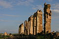
Remains of pillars at Oudna

Remains of a pillar at Mohamedia
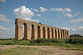
Restored pillars in Arabic style at Ouel Ellil

A vault of the La Malga cistern
.jpg)


bibliography
- Friedrich Rakob: The Roman spring shrine at Zaghouan in Tunisia . In Archaeological Gazette . Volume 84, 1969, pp. 284-300.
- Friedrich Rakob: The spring sanctuary in Zaghouan and the Roman aqueduct to Carthage . In: Roman communications . Volume 81, 1974, pp. 51-89.
- Friedrich Rakob: The Roman aqueduct of Carthage . In: J.-P. Boucher (Ed.): Journées d'études sur les aqueducs romains = Conference on Roman water supply systems, Lyon 26.-28. May 1977 . Paris 1983, pp. 309-318.
- H. Slim: Maîtrise de l'eau en Tunisie à l'époque romaine . In: G. Argoud et al. (Ed.): L'eau et les hommes en Méditerranée et en Mer Noire dans l'antiquité . Athens 1992, pp. 513-532.
- A. Wilson: Water supply in ancient Carthage . In: Carthage papers (= Journal of Roman Archeology. Supplementary series. Volume 28). Portsmouth, RI 1998, ISBN 1-887829-28-8 , pp. 65-102.