
Dreiherrenstein (Tännichtberg)
The Dreiherrenstein or Dreiecker ( Třípanský kámen in Czech ) is a historic landmark on the border between the Federal Republic of Germany and the Czech Republic near Sohland on the Spree in the Lusatian Uplands , which was listed as a historical monument until 2014 .
location
The Dreiherrenstein is located northwest of Neudorf in Tännicht. It stands on the ridge southwest of the Tännichtberg ( 461 m ) halfway to the children's mountain ( Liščí vrch , 480 m ) not far from the big bend on the boundary between Sohland an der Spree , Wehrsdorf and Hainspach ( Lipová ). The Oberlausitzer Bergweg and the border hiking trail “In the footsteps of the red wood ant” lead past the Dreiherrenstein .
A good 500 m to the west, the Wehrsdorf, Hainspach and Röhrsdorf ( Liščí ) districts meet at another bend in the border .
description

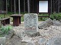
View of the border point with information board and hiking map

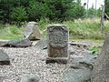
Top view in winter
South-east side with the coat of arms of August Siegmund von der Sahla (manor Obersohland)
South-west side with the coat of arms of Leopold Anton Altgraf von Salm-Reifferscheidt-Hainspach (manor of Hainspach)

North-west side with the coat of arms of the cathedral chapter Bautzen (Rittergut Wehrsdorf)


The prismatic boundary stone with a triangular ground plan bears a coat of arms of the then landlord on each of its sides. The southwest side bears the coat of arms of the Counts of Salm-Reifferscheidt-Hainspach, including the initials L: G: Z: S ( L eopold G raf z u S alm ); the south-eastern side has the coat of arms of the Lords of the Sahla and the initials A: S: V: d: S ( A ugust S iegmund v on d er S ahla ), the north-western side only bears the coat of arms of the Bautzen cathedral chapter.
The historic border mark is protected as a cultural monument and was restored at the beginning of the 2000s.
history
The boundary stone set in 1750 marked the border between the Bohemian manor of Hainspach and the Upper Lusatian manors Obersohland and Wehrsdorf.
swell
literature
- Around Bautzen and Schirgiswalde (= values of the German homeland . Volume 12). 1st edition. Akademie Verlag, Berlin 1967, p. 204.
Footnotes
- ↑ Border hiking trail "In the footsteps of the red wood ant" ( Memento of the original from January 8, 2017 in the Internet Archive ) Info: The archive link was inserted automatically and has not yet been checked. Please check the original and archive link according to the instructions and then remove this notice.
Web links
Coordinates: 51 ° 2 ′ 19.2 " N , 14 ° 22 ′ 53.2" E