Tännichtberg
| Tännichtberg | ||
|---|---|---|
|
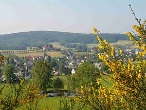
View from the north over Wehrsdorf to Tännichtberg |
||
| height | 461.2 m | |
| location | Free State of Saxony , Germany | |
| Mountains | Lusatian highlands | |
| Coordinates | 51 ° 2 '32 " N , 14 ° 23' 12" E | |
|
|
||
| rock | Granodiorite | |
The Tännichtberg ( 461.2 m ) is a mountain in the Bautzen district in Saxony . It is located near the Czech border on the boundary between Sohland an der Spree and Wehrsdorf in the Lausitzer Bergland .
geography
The Tännichtberg rises south of Wehrsdorf on the German-Czech border. It is part of a wide ridge of the third mountain range of the Lusatian Mountains, from which the Prinz-Friedrich-August-Höhe ( 469 m ) and the Kinderberg ( Liščí vrch , 480 m ) in the south and the Petersberg ( Srní , 463 m ) in the west rise further peaks of almost the same height. To the north the mountain falls to the valley of the Kaltbach and east to the valley of the Tännichtwasser ; to the west the black raft and the Tännichtfluss form a gentle bottom. The "Tännicht" forest area, which covers the ridge, is, like the Black Bush and the Brandbusch, part of the extensive border forest between Upper Lusatia and Bohemia . To the northeast of the mountain is the Tännichtteich, to the southwest not far from the bend in the border on the ridge of the Dreiherrenstein .
At the foot of the Tännichtberg are Wehrsdorf in the north, Pilzdörfel in the northeast , Tännicht in the east, Obersohland in the southeast, Neudorf in the south and Röhrsdorf ( Liščí ) in the southwest .
history
Tännicht, located between the Wehrsdorfer and Röhrsdorfer Tal, remained uninhabited for a long time. It was not until the end of the 17th century that the Lords of the Sahla began to settle the corridors belonging to the Obersohland manor at the foot of the Tännichtberg. In the headwaters of the Tännichtwasser, peat was dug and ponds operated east of the mountain. The miles sheet shows that at the beginning of the 19th century, both the peat digging and most of the ponds near Neuobersohland were abandoned. Quarries were operated on the east and south-east slopes of Tännichtberg in the 19th century.
In the 1970s, the Sohland winter sports enthusiasts built a new winter sports center on the eastern slope of the Tännichtberg, which replaced the previous sports facilities on the Schwarzen Koppe . The Tännichtschanze was built between 1969 and 1972. In 1975 the school jump was built, a downhill slope was leveled and a 375 m long hook tow lift was built. The Schanzenbaude with restaurant, club room, overnight accommodation and sauna was completed in 1981. In 1998 the municipality of Sohland had a new tow lift built.
swell
literature
- Around Bautzen and Schirgiswalde (= values of the German homeland . Volume 12). 1st edition. Akademie Verlag, Berlin 1967, pp. 211–212.

