Beckenberg
| Beckenberg | ||
|---|---|---|
|
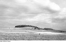
Eibau with Beckenberg in the background |
||
| height | 407.6 m | |
| location | Saxony ( Germany ) | |
| Mountains | Lusatian highlands | |
| Coordinates | 50 ° 58 '59 " N , 14 ° 40' 18" E | |
|
|
||
| rock | basalt | |
| particularities | Shack | |
The Beckenberg north of Eibau in the southern district of Görlitz is a mountain in the Lusatian highlands with a height of 407.6 m above sea level. NN, which drops off markedly on three sides. The mountain probably got its name because of its geographical location isolated about 50 meters above the valley floor of the southern Eibauer valley basin of the Landwasser . Other lower peaks made of nepheline basanite are separated by narrow saddles in a south-easterly direction.
geology
Tertiary tuffs can be found on the northern slope under the edge zone of the Leutersdorf basalt cover, to which the Beckenberg belongs. Therefore, the arable soil also has a noticeable reddish to light purple color due to the weathering material. Furthermore, the groundwater is dammed up close to the surface by the rock, which is why only extensive drainage, including on the sloping central slope, allows agricultural cultivation. The tertiary tuffs, underlain by Seidenberger granodiorite, seem to be related to the occurrence at a height of 376.6 meters, which is in the immediate vicinity where the field boundaries of Eibau , Ruppersdorf and Oberoderwitz meet. The basanite is exposed on the western slope in a former quarry.
The 385.6 meter high Kühnelsberg, one kilometer to the south-east, was named after the Oderwitz- based farmer Christian Kühnel, who sold and divided up his property in 1717. The former quarry at its top, which shows vertical columns, was abandoned in 1935 and is now completely overgrown with wood.
history
Based on the low grinding capacity of the water mills in the village of Eibau, the city council in Zittau allowed the erection of a windmill on the elevation, which was still called Beckerberg or Bäckerberg until the 19th century. In 1759 the mill was built together with a house and a barn. The windmill was operated from 1759 to 1900. In addition to the windmill on the Beckenberg, there were two other windmills on Eibauer Flur, the Röthemühle located two kilometers to the north and another windmill south of the Beckenberg.
After the Eibau country brewery was founded in 1810 by the citizens of the city of Zittau, who had the right to brew, the fresh spring water required for the brewing process was brought in from the Beckenberg through a wooden pipeline, among other things. In return, the miller vom Beckenberg received a concession to serve beer, which was difficult to obtain at the time.
Baude and former local history museum
In 1905 the mountain inn "Beckenbergbaude" was built, which was used as a restaurant (to this day) and holiday home as well as a children's holiday camp for VEB Bekleidungswerke Neugersdorf during GDR times. The barn of the former mill right next to it was converted into a local museum by the community and expanded in 1953/54 with an exhibition room. The Heimat- und Humboldtmuseum Eibau, which was established between 1864 and 1945 as a result of the collecting activities of the Humboldtverein von Alteibau, a scientifically oriented Heimatverein, showed until April 2012 a collection of natural objects (e.g. on geology, fauna) as well as an exhibition on the local history of Eibau Curiosities, rarities and two movable Christmas cribs with 80 Bohemian crib figures. Today (since October 31, 2012) the museum is located in the Faktorhof on the B 96 directly in the local area of Eibau.
A road leads from the village of Eibau from the B 96 to the top of the mountain.
literature
- The south-eastern Upper Lusatia with Zittau and the Zittau Mountains (= values of the German homeland . Volume 16). 1st edition. Akademie Verlag, Berlin 1970.
Individual evidence
Web links


