Ruppersdorf / OL
|
Ruppersdorf
City of Herrnhut
Coordinates: 50 ° 59 ′ 56 " N , 14 ° 43 ′ 26" E
|
|
|---|---|
| Height : | 322 m above sea level NN |
| Area : | 17.89 km² |
| Incorporation : | March 1, 1994 |
| Postal code : | 02747 |
| Area code : | 035873 |
|
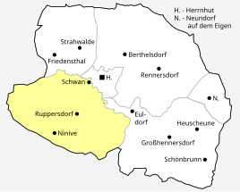
Location of Ruppersdorf in the area of the city of Herrnhut (as of January 1, 2013)
|
|
Ruppersdorf / OL is part of the municipality of Herrnhut in the Görlitz district in Upper Lusatia (OL) in south-east Saxony .
Geography and traffic
The six kilometer long district of Ruppersdorf is located in the southern part of the district of Görlitz. It is located about 2.5 kilometers southwest of Herrnhut in the Eastern Upper Lusatia (natural area). State road 144 leads from Herrnhut to Oderwitz through the municipality. The community is located on the (disused) Zittau – Löbau railway line with a stop. The Ruppersdorfer Wasser (Ruppersdorfer Bach) flows through the village . This rises in two source arms not far from the Kottmarhäuser at 440 m above sea level. NN. The water for the Ruppersdorfs drinking water pipeline, which was built in 1928 and is no longer used, is collected a little further downstream. Up to the confluence with the Petersbach , the watercourse overcomes a gradient of 155 meters. The center of the village (church) is 355 m above sea level.
history
The place Ruppersdorf was first mentioned in 1320 as Ruperti villa . The name means village of a Ruotberht or Ruotbreht (Ruppert). The place name changed from 1355: Ruprechtisdorf to 1363: Rupertiuilla, Ruprichstorf, 1416: Ruprechtsdorff, Ruperti villa, 1426: Ruperßdorff, 1485: Rupperßdorff, 1543: Ruppersdorff to 1791: Ruppersdorf. In 1875 a distinction was made between Niederruppersdorf and Oberruppersdorf. The location is also mentioned in a document dated May 15, 1324, which is in the Prague State Central Archives (from REGESTA BOHEMIAE ET MORAVIAE by Josephi Emmler Pragae 1890, page 385, no. 987). The two manors Ober- and Niederruppersdorf were owned by the von Nostitz family from 1540 to 1830 .
The rural community of Ruppersdorf was formed in 1930 from Ober- and Niederruppersdorf.
The originally independent community of Ruppersdorf, a forest hoof village from the former districts of Schwan (-häuser) and Ninive (Neu-Oberruppersdorf), became a district of Herrnhut in 1994.
There used to be a number of watermills and sawmills on the Ruppersdorfer Wasser. The Hempelmühle milling facility (Untere Dorfstraße 19) was shut down in 1958, and the associated bakery in 1971. The Elßner mill with undershot mill wheel (Großhennersdorfer Straße 30) and the castle mill (near Niederruppersdorf Castle) used to work as a sawmill. The Ruppersdorfer Wasser and the Petersbach often overflowed their banks. On June 14, 1880, great damage was caused by a flood. 7 buildings were destroyed and 41 damaged, 7 people drowned and 106 lost their homes. Further floods are documented for the years 1883, 1887 and 1897 to 1900. Also in 1966, 2010 and 2013 Ruppersdorf was hit by a major flood.
After the introduction of official street names in 1982, the old separation into Niederruppersdorf (his houses had the letter A) and Oberruppersdorf (with the letter B) no longer existed.
Administrative affiliation: 1777: Görlitzer Kreis , 1843: District Court of Löbau, 1856: Herrnhut Court Office, 1875 : District Authority of Löbau , 1952: District of Löbau , 1994: District of Löbau-Zittau , 2008: District of Görlitz
Population development
| year | Residents | ||
|
|
Niederruppersdorf | Oberruppersdorf | Ruppersdorf |
| 1777 | 13 obsessed men , 31 gardeners , 42 cottagers , 2 desolate farms |
8 possessed men , 29 gardeners , 16 cottagers , 3 desolate farms |
- |
| 1834 | 939 | 793 | - |
| 1855 | 1,064 | 912 | - |
| 1871 | 1,186 | 945 | - |
| 1890 | 1,213 | 856 | - |
| 1910 | 1,201 | 740 | - |
| 1925 | 1,194 | 780 | - |
| 1930 | to Ruppersdorf | to Ruppersdorf | - |
| 1939 | - | - | 1,860 |
| 1946 | - | - | 2,186 |
Culture and sights
- Ruppersdorf Church (in Niederruppersdorf) with the oldest bell in Upper Lusatia
- Lower Castle (former moated castle) with castle pond, built by Andreas Hünigen in 1752
- Upper lock
- numerous half-timbered houses
- Railway viaduct
Sons and daughters
- Max von Saurma (1836–1909), Silesian landowner and member of the Prussian manor house
literature
- Between Löbau and Herrnhut (= values of the German homeland . Volume 56). 1st edition. Verlag Hermann Böhlaus successor, Weimar 1996, ISBN 3-7400-0935-7 .
- My hometown Ruppersdorf . Publisher: City of Herrnhut. Editing: Christel Hansel, Production: Winter Druck
- Cornelius Gurlitt : Ruppersdorf. In: Descriptive representation of the older architectural and art monuments of the Kingdom of Saxony. 34. Issue: Official Authority Löbau . CC Meinhold, Dresden 1910, p. 513.
- Wasserschloss Niederruppersdorf, In: Dr. Helmuth Gröger: Castles and palaces in Saxony, Heimatwerk Sachsen publishing house, 1940, pp. 170–171
Individual evidence
- ^ Niederruppersdorf in the Digital Historical Directory of Saxony
- ↑ Oberruppersdorf in the Digital Historical Directory of Saxony
- ^ Ruppersdorf / OL in the Digital Historical Directory of Saxony
- ↑ CFT Rudowsky: Directory of the entire localities of the Kingdom of Saxony ... after the census on December 3, 1855. Ramming, Dresden 1857, p. 49.
- ↑ CFT Rudowsky: directory of whole villages of the Kingdom of Saxony ... after counting on 3 December 1855. Ramming, Dresden 1857 S. 53rd


