Hutberg (Dürrhennersdorf)
| Hutberg | ||
|---|---|---|
|
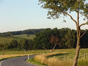
Hutberg seen from the south |
||
| height | 422.5 m | |
| location | Germany , Saxony | |
| Mountains | Lusatian highlands | |
| Coordinates | 51 ° 2 '46 " N , 14 ° 36' 50" E | |
|
|
||
| Type | Ridges | |
| rock | Granodiorite | |
The Hutberg (422 m) is a mountain in the Lausitzer Bergland in Saxony .
Location and surroundings
The Hutberg is located immediately east of the Dürrhennersdorf train station and south of the K 8677 (Bahnhofsstraße) and rises about 80 meters from the valley of the Großschweidnitzer water . To the east at the edge of the forest are two larger ponds (Engeleiteiche) which drain in the Hutbergwasser in a northerly direction into the Großschweidnitz water.
description
Its summit and the north and east slopes are covered with forest areas, the west and south slopes are occupied by agricultural land (grassland).
Blocks of granodiorite, some of which protrude far from the ground, are scattered around and in very different densities. In some areas they are completely absent. An approx. 4 m high and approx. 10 m long cliff ridge crowns the summit, which is also known as the Hutstein. To the south and south-east of it are numerous rock blocks, the edges of which, in contrast to the other blocks, look remarkably freshly weathered and angular. Granodiorite is in the abandoned quarry west of the summit.
Similar to the Hahneberg , since the implementation of modern forest management, the pure spruce stand has been replaced by a mixed stand of spruce, pine and larch interspersed with individual red oaks.
literature
- Between Strohmberg, Czorneboh and Kottmar (= values of our homeland . Volume 24). 1st edition. Akademie Verlag, Berlin 1974.


