
Dunure
|
Dunure Scottish Gaelic Dùn Iubhair |
|||
|---|---|---|---|
 |
|||
| Coordinates | 55 ° 24 ′ N , 4 ° 45 ′ W | ||
|
|||
| Residents | 492 (1991 census) | ||
| administration | |||
| Post town | AYR | ||
| ZIP code section | KA7 | ||
| prefix | 01292 | ||
| Part of the country | Scotland | ||
| Council area | South Ayrshire | ||
| British Parliament | Ayr, Carrick, and Cumnock | ||
| Scottish Parliament | Carrick, Cumnock and Doon Valley | ||

Dunure ( Gaelic : Dùn Iubhair ) is a village in the Scottish council area of South Ayrshire . It is located in the west of the region around eight kilometers northwest of Maybole and ten kilometers southwest of Ayr at the transition from the Firth of Clyde to the Irish Sea . To the south, between Dunure and Croy , is the Electric Brae , an optical illusion that makes vehicles seem to be rolling up the hill.
history
The history of Dunure is linked to Dunure Castle , which is located on a cape on the outskirts of the village. The Kennedy clan , who later provided the Earls of Cassillis , had Dunure Castle built in the 13th century and used the castle as one of their headquarters. There is evidence that Queen Mary of Scots spent three nights at Dunure Castle. The decline of the complex is dated to the middle of the 17th century. In 1694 Dunure Castle was described as a ruin.
However, Dunure did not grow until a port was established in 1811. The construction on the rocky coast without a naturally protected location proved to be complicated and costly. A harbor basin was driven into the rock and the entrance was marked with a lighthouse. The total cost was £ 50,000. After a while, however, the port was only rarely used, which seems unusual on a long stretch of coast without natural harbors and landing sites. Today it is mainly used for recreational purposes.
Between 1961 and 1991 the population of Dunures fluctuated between 452 and 527.

Port facilities
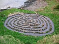
Modern labyrinth


traffic
Dundonald is located directly on the A719 , which is the main thoroughfare. The A719 connects the village to the A77 . In 1906 the Glasgow and South Western Railway opened the Maidens and Dunure Railway . The trains ran between Ayr and Girvan . However, the line was only used moderately and the Dunure station was closed again in 1933. After the entire line was closed in 1968, the track was dismantled. With the Glasgow Prestwick Airport is an international airport located about 18 kilometers north-east.
Individual evidence
- ↑ a b Information in the Gazetteer for Scotland
- ^ List of Gaelic expressions
- ↑ a b Entry in the Gazetteer for Scotland
- ^ Entry on Dunure Castle in Canmore, the database of Historic Environment Scotland (English)
- ^ Information from the South Ayrshire Council
- ^ Dunure in: FH Groome: Ordnance Gazetteer of Scotland: A Survey of Scottish Topography, Statistical, Biographical and Historical. , Grange Publishing, Edinburgh, 1885.
- ↑ Information on railscot.co.uk