Elie (Manitoba)
| Elie | ||
|---|---|---|
| Location in Manitoba | ||
|
|
||
| State : |
|
|
| Province : | Manitoba | |
| Coordinates : | 49 ° 54 ′ N , 97 ° 45 ′ W | |
| Height : | 400 m | |
| Residents : | 550 (as of 2011) | |
| Time zone : | Eastern Time ( UTC − 5 ) | |
| Postal code : | R0H 0H0 | |
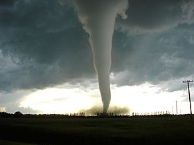
 Canada's first F5 tornado as it approached the site |
||
Elie ( ˈiːlaɪ ) is a non-incorporated settlement and Local Urban District in the Rural Municipality of Cartier in the Canadian province of Manitoba .
geography
The village is about 30 km west of Winnipeg on the Trans-Canada Highway . The La Salle River flows through the place , the Assiniboine River north of Erie forms the northern border of the Municipality of Cartier, other places near Elie are St. Eustache, Dacotah and Springstein.
Tornado in June 2007
On June 22, 2007, Elie was hit by an F5 tornado . It is the strongest tornado ever recorded in Canada. He damaged a flour mill, destroyed several buildings and tore two sturdy houses from their foundations. A house was swept away 100 meters. The tornado only injured one person and no one was killed because Environment Canada residents were warned long enough to seek refuge.
Economy and Infrastructure
The main industry is agriculture . The transmission mast of the municipal TV station CHMI-DT was built in 1986.
supporting documents
- ↑ 2011 Community Profiles - Census Subdivision
- ^ Local Urban Districts Regulation . Government of Manitoba. April 23, 2016. Accessed August 2019.
