Emmeringer Leite
| Emmeringer Leite | ||
|---|---|---|
|
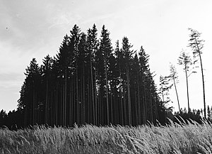
Forest on the Emmeringer Leite |
||
| height | 561 m | |
| location | Fürstenfeldbruck district , Bavaria , Germany | |
| Coordinates | 48 ° 10 '26 " N , 11 ° 17' 39" E | |
|
|
||
| Type | Terminal moraine | |
The Emmeringer Leite is an elongated, wooded ridge along the Amper in the Bavarian district of Fürstenfeldbruck . It is the northern part of a terminal moraine , the rock of which probably dates back to the Mind Ice Age . The ridge is around 4 km long, up to 1.5 km wide and 561 m high. It rises about 40–50 m above the surrounding area. Emmering is a place that lies to the west of the ridge, Leite means 'mountain slope' in the southern German language area.
At the northern foothills of the Emmeringer Leite is the Burgstall Roggenstein , at the south the Burgstall Gegenpoint . There are prehistoric burial mounds and funnel pits in several places on the ridge . Funnel pits are round holes in the ground that either served as a substructure for prehistoric dwellings or as storage space for supplies.
Individual evidence
- ^ Paul-Eckard Salzmann: Geology and Geography. In: Fürstenfeldbruck district. Nature, history, culture. 1992, p. 18 f. - See also: Geographic data atlas for Bavaria of the Bavarian State Office for the Environment.
- ↑ Duden: Etymological dictionary. Keyword Leite .
- ↑ Monument viewer ( Memento of the original from April 23, 2016 in the Internet Archive ) Info: The archive link was inserted automatically and has not yet been checked. Please check the original and archive link according to the instructions and then remove this notice. of the Bavarian State Office for Monument Preservation.

