Errikousa
| Errikousa (Ερρείκουσα) | ||
|---|---|---|
| Errikousa from space | ||
| Waters | Ionian sea | |
| Archipelago | Diapontic Islands | |
| Geographical location | 39 ° 53 ′ 0 ″ N , 19 ° 35 ′ 0 ″ E | |
|
|
||
| length | 2.8 km | |
| width | 2 km | |
| surface | 4 km² | |
| Highest elevation | Merlera 130 m |
|
| Residents | 496 (2011) 124 inhabitants / km² |
|
| main place | Errikousa | |
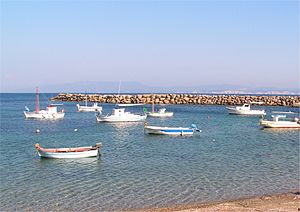
| View of the port of Errikousa | ||
Errikousa ( Greek Ερρείκουσα [ ɛˈrikusa ] ( f. Sg. ) Older spelling also Erikoussa (Ερεικούσσα)) is the northernmost of the Othonian or Diapontian Islands . The island belongs to Greece and is about 11 km from the coast of Corfu . With an extension of about 2 × 2 km and an area of 4 km², it is the second largest of the Diapontian or Othonian Islands, on which the few inhabitants mainly live from agriculture, especially olive growing, as well as modest fishing and tourism . The highest point is the Merlera at 130 m .
Until 2010 Errikousa was an independent municipality ( Greek κοινότητα kinotita ) within the prefecture of Corfu , since the administrative reform of 2010 it has belonged to the new municipality of Kerkyra , where it has since formed one of 15 municipal districts. The main locations are the pier of Porto and the eponymous hamlet of Errikousa on the east coast.
The island can be reached with the regular ferry service (in good weather) with the city of Corfu and seasonally with the northwestern Corfiot tourist resorts. So far, the places on the island have hardly been affected by tourism and are therefore very quiet. Errikousa has a few hotels and long sandy beaches with clear water.
Individual evidence
- ↑ Results of the 2011 census. ( MS Excel ; 2.6 MB) National Statistical Service of Greece (ΕΛ.ΣΤΑΤ)


