Diapontic Islands
| Diapontic Islands | ||
|---|---|---|
| The Diapontian Islands from the northwest | ||
| Waters | Mediterranean Sea | |
| archipelago | Ionian islands | |
| Geographical location | 39 ° 49 ′ N , 19 ° 30 ′ E | |
|
|
||
| Number of islands | 11 | |
| Main island | Othoni | |
| Residents | 1700 (2001) | |
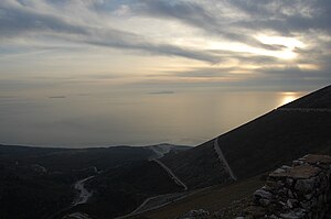
| Errikousa (left), Mathraki (center) and Othoni (right) seen from the north of Albania | ||
The Diapontian Islands ( Greek Διαπόντια νησιά Diapóndia nisiá ( n. Pl. ), Also Othonian Islands ) are an archipelago in the north of the Ionian Islands, northwest of Corfu . They form the most north-western group of islands in Greece . Until 1947, Sazan was also included in the archipelago.
About 1,700 people live on the three inhabited islands of Othoni , Errikousa and Mathraki . The three inhabited islands formed separate communities until 2010; On January 1, 2011, they were incorporated into the municipality of Kerkyra , where they have since formed municipal districts and elect their own local representatives as localities.
The archipelago still includes a few uninhabited islets and rocky reefs.
There is a (regular) ferry connection with Corfu's capital Kerkyra .
The individual islands
| Surname | Greek name | Parish | highest elev. | location |
|---|---|---|---|---|
|
Errikousa (Merlera) |
η Ερρείκουσα (Μερλερά) |
Erikoussa | 130 m | 39 ° 53 ′ 16 ″ N , 19 ° 35 ′ 0 ″ E |
|
Othoni (Fanos) |
οι Οθωνοί (Φανός) |
Othoni | 393 m | 39 ° 51 '8 " N , 19 ° 23' 55" E |
| Castrino | το Καστρινό | Othoni | ||
| Ostrac | το Όστρακο | Othoni | ||
|
Mathraki (Malthaki) |
το Μαθράκι (Μαλθάκι) |
Mathraki | 155 m | 39 ° 46 ′ 9 ″ N , 19 ° 31 ′ 21 ″ E |
| Diakopo | το Διάκοπο | Mathraki | 39 ° 45 ′ 50 ″ N , 19 ° 35 ′ 19 ″ E | |
| Diaplo | το Διάπλο | Mathraki | 39 ° 46 ′ 3 " N , 19 ° 35 ′ 34" E | |
| Karavi | το Καράβι | Mathraki | 39 ° 45 ′ 50 ″ N , 19 ° 35 ′ 19 ″ E | |
|
Lipso (Varka) |
η Λειψώ (Βάρκα) |
Mathraki | ||
|
Plaka (Angyra) |
Πλάκα (Άγκυρα) |
Mathraki | ||
| Trachia | η Τραχειά (Τραχιά) |
Mathraki | 39 ° 46 ′ 21 ″ N , 19 ° 29 ′ 44 ″ E |
Individual evidence
- ↑ Information. (PDF) Greek Statistical Service
- ↑ The data follow information on GTP


