Paxi
|
Municipality of Paxi Δήμος Παξών (Παξοί) |
||
|---|---|---|
|
|
||
| Basic data | ||
| State : |
|
|
| Region : | Ionian islands | |
| Regional District : | Kerkyra | |
| Geographic coordinates : | 39 ° 12 ′ N , 20 ° 10 ′ E | |
| Area : | 30.121 km² | |
| Residents : | 2,300 (2011) | |
| Population density : | 76.4 inhabitants / km² | |
| Community logo: | ||
| Seat: | Gaios | |
| LAU-1 code no .: | 3202 | |
| Districts : | no | |
| Local self-government : |
1 city district 3 local communities |
|
| Website: | www.paxi.gr | |
| Location in the Ionian Islands region | ||
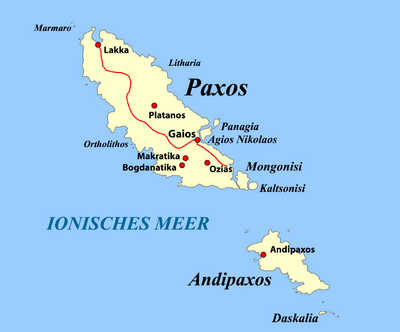
Paxi ( Greek Παξοί ( m. Pl. )) Is a Greek archipelago in the Ionian Sea , which is one of the Ionian Islands and at the same time forms a municipality in the Kerkyra regional district of the Ionian Islands . It consists of the inhabited islands of Paxos or Paxi and Andipaxos or Andipaxi as well as numerous other uninhabited islets and rocks. It has 2,300 inhabitants (2011).
The individual islands
| Surname | Greek name | location |
|---|---|---|
| Marmaro (Exo Lithari) |
Μάρμαρο (Έξω Λιθάρι) |
39 ° 14 ′ 29 ″ N , 20 ° 7 ′ 21 ″ E |
| Paxos (Paxi) | Παξός (Παξοί) | 39 ° 12 '25 " N , 20 ° 9' 49" E |
| Ortholithos | Ορθόλιθος | 39 ° 11 ′ 44 ″ N , 20 ° 9 ′ 6 ″ E |
| Litharia 4 small rocks |
Λιθάρια | 39 ° 13 ′ 29 ″ N , 20 ° 10 ′ 15 ″ E |
| Agios Nikolaos (Ai Nikola) |
Άγιος Νικόλαος (Αη Νικόλα) |
39 ° 12 ′ 0 ″ N , 20 ° 11 ′ 20 ″ E |
| Panagia | Παναγία | 39 ° 12 ′ 15 " N , 20 ° 11 ′ 40" E |
| Lithari | Λιθάρι | 39 ° 12 ′ 20 " N , 20 ° 11 ′ 46" E |
| Agios Ioannis | Άγιος Ιωάννης | |
| Mongonisi | Μογγονήσι | 39 ° 10 ′ 54 " N , 20 ° 12 ′ 28" E |
| Kaltsonisi Kaltsionisi |
Καλτσονήσι Καλτσιονήσι |
39 ° 10 ′ 46 " N , 20 ° 12 ′ 47" E |
| Katergo | Κάτεργο | |
| Andipaxos | Αντίπαξος | 39 ° 6 ′ 57 " N , 20 ° 13 ′ 54" E |
| Daskalia | Δασκάλια | 39 ° 7 ′ 49 " N , 20 ° 14 ′ 56" E |
| Plaka | Πλάκα | |
| Psilos | Ψηλός | |
| Trypitus | Τρυπητός | |
| Bourdoumbou | Μπουρδουμπού | |
| Xerosfoungaria | Ξεροσφουγγάρια |
Community structure
After the annexation of the Ionian Islands to Greece, a community Gaios (gr. Dimos Gaianon Δήμος Γαϊανών) was founded in 1866 , which included the archipelago. This municipality was divided into four rural parishes in 1912, which together formed the province of Paxi. In 1957 the rural community of Gaios was renamed Paxi. In 1997 the municipality of Paxi was formed from these municipalities and the province was abolished. Since 2011, Paxi has been divided into the Gaios district and three local communities, each of which has its own local representation. The population figures come from the results of the 2011 census.
- City district Gaios (Γαΐος, 1,196 inhabitants), the actual village Gaios with 498 inhabitants is the seat of the municipality.
- Local community Lakka (Λάκκα, population 446, village 147)
- Local community Longos (Λογγός, 298 inhabitants, village 81)
- Local community Magazia (Μαγαζιά, 360 inh.) With the village Magazia (91) and Platanos (99)
Andipaxos is still permanently inhabited by 20 people. Up to 150 people live there in summer. It belongs administratively to the municipality of Gaios.
Web links
- Portrait (Greek)
Individual evidence
- ↑ a b Results of the 2011 census, Greek Statistical Office (ΕΛ.ΣΤΑΤ). ( Memento from June 27, 2015 in the Internet Archive ). (Excel document, 2.6 MB).
- ↑ Administrative history of the database of the EETAA (Greek Society for Development and Decentralization) ( Memento of the original from October 16, 2013 in the Internet Archive ) Info: The archive link was inserted automatically and has not yet been checked. Please check the original and archive link according to the instructions and then remove this notice.


