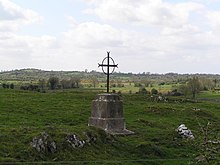
Esker Riada
Esker Riada ( Irish Eiscir Riada ) is a system of mountain ranges that stretch across the center of Ireland between Dublin and Galway .
geography
The Esker Riada is a collection of ground moraines (Eskers) that characterize the landscape in Dublin , Meath , Kildare , Westmeath , Offaly , Roscommon and Galway counties . More Eskers can be found in the Teernacreeve region of Westmeath, stretching from Kilbeggan to Tyrrell Pass. The Eskers are relatively low, elongated elevations made up of sand, gravel and boulders . They were deposited on the bottom and edge of the glaciers by water currents during the ice ages and remained when the glaciers disappeared at the end of the last ice age about 10,000 years ago.
history
After a battle in 123 AD at Maynooth , the island was divided into two units along the Eskers: " Leath Chuinn " (Conn's half) in the north and " Leath Mhogha " (Mogha's half) in the south.
Because the hills offered a safe passage through the marshes of the Irish Midlands , they have always been a major artery from east to west of Ireland. An old name "An tSlí Mhór" literally means "The Great Way".
The "great way" also formed, for example, the connection from Durrow Abbey to the monastery settlement of Clonmacnoise , which was built at the point where the Shannon breaks through the Esker Riada.
In contrast to the surrounding moors, the Ice Age sands with their well-draining soils also offered good agricultural areas.
present
The Esker Riada still serves as a highway to this day. The route of the main road N6 from Dublin to Galway still follows the course of the Esker and agriculture is still practiced along the hill. A spur extends into Dublin to High Street and Wood Quay, where the Viking settlement and the original fort stood, from which Dublin got its name Átha Cliath , and from there the hill continues to the south-west through Kilmainham to Greenhills Road .
The Eskers are now also a valuable resource for building materials and are mined in many places for sand and gravel extraction. Fortunately, the importance for the cultural landscape was recognized and many areas were placed under protection. The County Offaly strives even getting the Esker Riada for World Heritage to explain.
Individual evidence
- ↑ a b c Esker Riada
- ^ Geology of British Isles, "The Isles Project
- ↑ ireland.com / Focus / Heritage Ireland
- ^ What lies beneath; It has taken millions of millennia for the Irish landscape to evolve - and the result is unique in its diversity, writes Eileen Battersby - Science - redOrbit
- ↑ Section 2 Development Strategies and Policies:
