
Phalasarna

Phalasarna ( Greek Φαλάσαρνα ( f. Sg. )) Refers to an ancient port city on the west coast of the Greek island of Crete . The archaeological sites of the ancient city are about eight kilometers west of the city of Kissamos .
The current settlement of Falasarna (also Falassarna ) is located south of the ruins of Phalasarna along the coast of the Bay of Livadia . It belongs to the place Platanos in the municipality of Kissamos . The main source of income for the Cretans living there is agriculture, so there are countless greenhouses in which mainly tomatoes, but also bananas are grown, and tourism . Of tourist interest are the long sandy beaches with their bizarre rock formations caused by the uplift of the seabed, as well as the remains of the port, settlement and temples of ancient Phalasarna.
history

The historic Phalasarna on the north west coast of Crete was founded around the 5th century BC. Founded as a port of the inland city of Polyrrhenia and named after the nymph Phalasarna . The acropolis (upper town) built on Cape Koutri with the temple of Artemis Diktynna was protected from the land side by a wall with square bastions. The city wall has been preserved up to a height of eight meters. In the valley in front of the wall was the city's necropolis . Excavations there brought box graves from the 6th century BC. Until the end of the 4th century BC. With rich grave goods to days. To the south of the actual excavation sites is a stone-carved “ throne seat ”, the function of which is unclear. Nearby, west of the throne, lies a sarcophagus in an olive grove .

Phalasarna owned a closed artificial naval port , called Kóthon (tall, bulbous jug) in antiquity , which was connected to the sea by a canal to the west. It was carved out of the coastal rocks to the extent of 100 x 75 meters. A second canal allowed the exit 100 meters behind the north side of the Acropolis. As a fortification, the port had four towers from the 4th century BC. Chr., Which are partially preserved. A large earthquake on July 21, 365 AD and an associated increase in the land mass at Phalasarna by six to nine meters drained the harbor basin.
During the Hellenistic period, Phalasarna, with its sheltered harbor, was a rich trade and shipping center with its own fleet and coinage. The city's coins depict a female figure or two dolphins on one side and a trident with the letters “Φ Α” on the other. In the 3rd century BC Phalasarna was allied with the Ptolemies as an important trading post and controlled the sea west of the island. The main source of income for the polis , however, was piracy . In 184 BC It was conquered by the city of Kydonia . Severe damage to the buildings occurred in 67 BC. At the time of the conquest of Crete by the Romans , who consolidated their takeover by destroying pirate bases. As a result of the tectonic uplift in the 4th century AD and the associated silting up of the port, the city was deprived of its economic basis.
Excavations
Rescue excavations in the necropolis were carried out from 1966 by Yannis Tzedakis, the then head of the antiquities administration of Chania . More than 70 graves were uncovered , some of them stone box graves , some burials in Pithoi . The oldest graves date from the 6th century BC. Chr .; A red-figure pelike was found in a 4th century grave. In the area of the graves there was also a stone throne about two meters high.
From 1986 Elpida Hadjidaki from the Greek Antiquities Service and Frank J. Frost from the University of California, Santa Barbara, explored the port area . Among other things, they found a fortified gate, two towers, a cistern, qais at the harbor basin and a road.

Pelike with Eros and Maenad
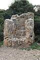
stone throne

Walls

Harbor tower

Tubs

cistern


literature
- Elpida Hadjidaki: Preliminary Report of Excavations at the Harbor of Phalasarna in West Crete. American Journal of Archeology, 92 (1988) pp. 463-479.
- Frank Frost, Elpida Hadjidaki: Excavations at the Harbor of Phalasarna in Crete . Hesperia 59 (1990) pp. 513-27.
supporting documents
- ↑ SC Stiros, S. Papageorgiou: Seismicity of Western Crete and the destruction of the town of Kisamos at AD 365: Archaeological evidence . In: Journal of seismology . tape 5 , no. 3 , 2001, p. 381-397 , doi : 10.1023 / A: 1011475610236 .
- ^ Yannis Tzedakis: "Antiquities and Monuments of West Crete." Archaeologikon Deltion 24 (1969) pp. 433-434
Web links
- Phalasarna - Ancient City. Archaeological Atlas of Crete: Archaeological Sites. Forth: Institute for Mediterranean Studies, accessed October 10, 2016 .
- Falasarna, Greek Ministry of Culture , Greek
Coordinates: 35 ° 30 ′ 35 " N , 23 ° 34 ′ 9" E