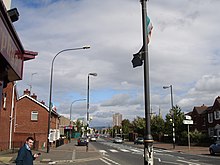
Falls Road
The Falls Road ( Irish Bóthar na bhFál ) is the main street of a predominantly Catholic , Republican- minded Irish residential area west of the center of the Northern Irish capital Belfast . In their neighborhood is the strongly Protestant - unionist Shankill district around Shankill Road , from which the Falls district is separated by fences, so-called peace lines , to separate the conflicting parties.
history
The quarter was traditionally strongly socialist (among other things, the Scottish- Irish socialist and trade unionist James Connolly lived here at times ). From the Falls Road, pro-Irish Republicans began their campaign for more civil rights in Northern Ireland (e.g. equal opportunities in the labor market) and for an end to their discrimination in the late 1960s . Radical pro-British unionists opposed them. The Falls district thus became one of the main theaters of the Northern Irish civil war, the so-called Troubles , especially in 1969 and 1970 . The British army was sent to the area to defuse the situation, but after the Republicans initially trusted their neutrality, it was increasingly perceived as an occupying power. In response to attacks by the Republican extremist PIRA (Provisional IRA), the army imposed a three-day curfew on the area in early July 1970 ( Curfew Falls ). During the heyday of the Troubles, there were frequent firefights between the army and the paramilitary Official IRA . British troops remained present in the area until 2005.
Gaeltacht Quarter
The Irish language is widely spoken in the Falls area due to its Irish Republican background and is therefore also known as the Gaeltacht Quarter of Belfast.
Web links
Coordinates: 54 ° 35 ′ 36 " N , 5 ° 57 ′ 30" W.
