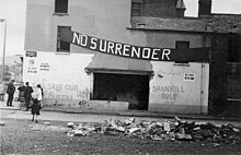
Shankill Road
The Shankill Road ( Irish Bóthar na Sean Chille ) is a central street in Belfast . It got its name from Protestant - British dominated district of The Shankill , one of the strongholds of the affiliation of Northern Ireland to the UK entering unionists (see Northern Ireland conflict ).
history
The first inhabitants of the area settled in a ring fortress at the confluence of the Ballygomartin River and the Forth River. The Shankill Road goes back to an old connection between the counties of Antrim and Down and got its name in 1831; the name The Shankill is an Anglicization of the Irish An tSeanchill , which means "the old church" - early written records from the 13th century indicate that Shankill Cemetery was the first Christian church in the greater area of what is now Belfast; According to tradition, St. Patrick founded the original church in 455 during a pilgrimage to Mount Slemish . In the Middle Ages, a church was built on this site for the community, which reached as far as Greencastle in the north and Malone in the south. The cemetery itself was Belfast's main cemetery for centuries and is over 1500 years old. It was probably already used in pre-Christian times, as suggested by the Bullaun Stone found in 1855 , which was probably used for rituals by the Celtic druids . In 1869 the City Cemetery was opened, and the Shankill Cemetery lost its status. Some famous personalities are buried here, including William Sterling and Isaac Nelson . The oldest existing tombstone goes back to 1685.
In the early second half of the 19th century Shankill became a center for linen production . By 1861 there were already 32 mills, most of which were around Shankill and Falls Road . In addition, many people had come to the city to escape the famine from 1845 to 1849 . These two factors created a growing need for housing, which the linen industrialists met with the construction of two-story houses with three bedrooms, a kitchen and shared toilets. These houses were of poor quality; most of them were demolished within 20 years of construction. In addition to the low industrial wages, construction activities could not keep up with immigration and up to three families had to live in one house. The people who came to Shankill Road were mostly people from County Antrim to the north, while the Falls Road was populated by Catholics from the west. This neighborhood led to major conflicts in the 20th century.
By 1890, most of the shankill was built on, so that the adjacent Woodvale quarter was created. Woodvale Park opened in 1888 to provide open space to the residents of densely populated Shankill. At the turn of the century the importance of the machine and shipbuilding industries increased; Companies such as the Harland & Wolff shipyard offered additional job opportunities.
During the second decade of the 20th century, many Shankill residents joined the Ulster Volunteer Force to use militant means to defend themselves against the Home Rule . The UVF joined the 36th Ulster Division of the British Army at the beginning of World War I and was used as the West Belfast 9th Battalion Royal Irish Rifles in the Battle of the Somme in early July 1916 . Of the 760 Shankill men who fought in the regiment , only 76 returned.
With the economic crisis of the 1930s, unemployment became overwhelming. As a result, the residents of Shankill and Falls Road came together for the first and only time in October 1932 to oppose the government of the time. During the Second World War, over 100 people were killed in the nightly bombing of the German Air Force, the " Belfast Blitz ".
With the second half of the 20th century came the decline of the linen, shipbuilding and mechanical engineering industries and the ensuing unemployment as well as the Northern Ireland conflict . In the 1960s, the Shankill's population fell from 76,000 to 26,000, and bombings and shootings were frequent until the 1990s. Today the neighborhood is undergoing extensive renovation, but remains a center of pro-British unionism in Northern Ireland with regular marches .
Web links
- Shankill History at shankilltourism.com
Coordinates: 54 ° 36 '15 " N , 5 ° 57' 5.2" W.


