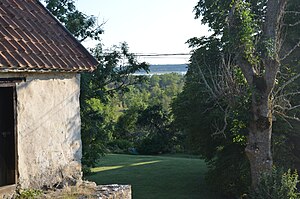
Fardumeträsk
| Fardumeträsk | ||
|---|---|---|

|
||
| Fardumeträsk from Fardume slott of view | ||
| Geographical location | Gotland , Sweden | |
| Tributaries | Bångå | |
| Drain | Bångå | |
| Islands | Storholmen | |
| Location close to the shore | Larbro | |
| Data | ||
| Coordinates | 57 ° 47 '19 " N , 18 ° 54' 47" E | |
|
|
||
| Altitude above sea level | 6.2 m ö.h. | |
| surface | 3.4 km² | |
| Maximum depth | 2 m | |
| Catchment area | 28.9 km² | |
|
particularities |
bird-rich lake |
|
Lake Fardumeträsk is the third largest lake in terms of area on the Swedish island of Gotland . It is located in the northeast of the island, 40 km northeast of Visby , 11 km northeast of Slite and 7 km east of Lärbro in the parish of Rute.
The lake contains water rich in lime, which leads to massive sediment banks due to the precipitation of the lime. Because the lake's water level was also lowered at the beginning of the 19th century, the lake is now very shallow and the sediment deposits sometimes reach almost to the surface of the water.
Because the lake is a breeding area for many birds, the island of Storholmen in the middle of the lake is not allowed to be entered from February to July. On the island there is a raised bog, which is unusual for Gotlandic standards, where there are even plants that are known not to thrive in a limestone-rich environment.
At the northern end of the lake are the medieval stone houses of Fardume slott .
Individual evidence
- ↑ a b Sjöareal och sjöhöjd. (PDF) In: Svenskt vattenarkiv (SVAR). Retrieved February 25, 2012 (Swedish, 3.32 MB).
- ↑ VattenWeb , Sveriges meteorologiska och hydrologiska institut (Swedish)
literature
- Jens Henrik Kloth, Ulf Lovén: Gotland's nature: en reseguide. Gotlands Fornsals förlag, Visby 2001, ISBN 9188036405 , p. 79.
Web links
- guteinfo.com about the Fardumeträsk I (Swedish)
- guteinfo.com about the Fardumeträsk II (Swedish)
- gotland.se about the Fardumeträsk (Swedish)
- Fardumeträsk. In: VISS (Vatteninformationssystem Sverige). Retrieved February 26, 2012 (Swedish).
